IMAGES TAKEN NEAR TO
Dalgleish Street, TAYPORT, DD6 9BB
Introduction
This page details the photographs taken nearby to Dalgleish Street, DD6 9BB by members of the Geograph project.
The Geograph project started in 2005 with the aim of publishing, organising and preserving representative images for every square kilometre of Great Britain, Ireland and the Isle of Man.

There are currently over 7.5m images from over14,400 individuals and you can help contribute to the project by visiting https://www.geograph.org.uk
Image Map (Loading...)


Getting Data...Please wait
Leaflet Map data © OpenStreetMap
Images are licensed for reuse under creativecommons.org/licenses/by-sa/2.0
Notes
- Clicking on the map will re-center to the selected point.
- The higher the marker number, the further away the image location is from the centre of the postcode.
Image Listing (138 Images Found)
Images are licensed for reuse under creativecommons.org/licenses/by-sa/2.0
Image
Details
Distance
4
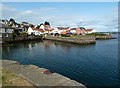
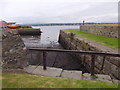
Old Harbour Tayport
Old harbour and houses to West of the harbour. The old lifeboat is the Duke of Kent.
Image: © Jim Bain
Taken: 13 Feb 2007
0.04 miles
5
Old Harbour, Tayport
Tide out. A former RNLI lifeboat (Duke of Kent) beached on pier at left.
Image: © Stanley Howe
Taken: 25 Jun 2015
0.04 miles
6
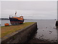
A retired lifeboat in Tayport
The former 'Duke of Kent'. For some more detail of it see Image
Image: © Stanley Howe
Taken: 25 Jun 2015
0.05 miles
7
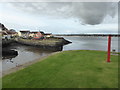
Tayport harbour
An alternative name shown on road signs for Tayport is 'Ferryport-on-Craig'. Since a ferry ran for years between here and Broughty Ferry on the north of the Firth of Tay, that seems a very logical name. But its derivation is more complex. Early 13th century documents show it as 'Partan Craig' (Gaelic for 'Crab Rock') which had been corrupted by English usage into Portincragge by 1415 and again into Port-in-Craige by the end of that century.
Image: © James Allan
Taken: 5 Mar 2012
0.05 miles
8
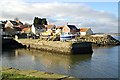
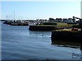
Tayport Harbour
The smaller part of the harbour to the left and seen from the central pier.
Image: © Chris Allen
Taken: 20 Oct 2016
0.05 miles
9
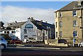
Bell Rock Tavern Tayport
This area around the new harbour car park and the bottom of Broad Street is dominated by the mural clad Bell Rock.
Image: © Jim Bain
Taken: 13 Feb 2007
0.05 miles
10
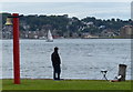
Fisherman at Tayport harbour
Broughty Ferry is about a mile away across the Firth of Tay.
Image: © Mat Fascione
Taken: 26 Jun 2017
0.05 miles