IMAGES TAKEN NEAR TO
Bank Street, NEWPORT-ON-TAY, DD6 8AU
Introduction
This page details the photographs taken nearby to Bank Street, DD6 8AU by members of the Geograph project.
The Geograph project started in 2005 with the aim of publishing, organising and preserving representative images for every square kilometre of Great Britain, Ireland and the Isle of Man.

There are currently over 7.5m images from over14,400 individuals and you can help contribute to the project by visiting https://www.geograph.org.uk
Image Map
Images are licensed for reuse under creativecommons.org/licenses/by-sa/2.0
Notes
- Clicking on the map will re-center to the selected point.
- The higher the marker number, the further away the image location is from the centre of the postcode.
Image Listing (78 Images Found)
Images are licensed for reuse under creativecommons.org/licenses/by-sa/2.0
Image
Details
Distance
1
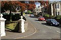
Grenada Brae, Newport
Looking up Grenada Brae from Tay Street.
Image: © Jim Bain
Taken: 14 May 2007
0.07 miles
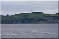
4
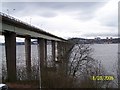
Tay Road Bridge and Dundee
Opened by the Queen Mother, on 18th August 1966, the Tay Road Bridge crosses the Tay estuary linking Newport in north east Fife with the City of Dundee.
Image: © Val Vannet
Taken: 22 Feb 2004
0.08 miles
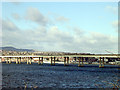
5
Tay Road Bridge
Looking north from Fife towards Dundee
Image: © Karl Peet
Taken: 18 Mar 2005
0.08 miles
6
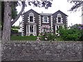
A villa on Tay Street, Newport-on-Tay
Does the name 'Grenada' suggests a West Indian trade connection at the time of construction?
Image: © Stanley Howe
Taken: 25 Jun 2015
0.09 miles
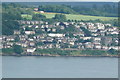
7
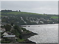
Newport -on -Tay
Newport from the Fife end of the bridge.
Image: © william
Taken: 6 Sep 2011
0.10 miles
8
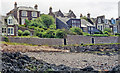
Newport beach
This was taken very close to the Tay Road Bridge in front of Wreckers Cottage looking towards Tay Street.
Image: © james dunlop
Taken: 12 Dec 2001
0.11 miles
9
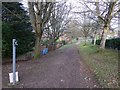
Norwood footpath on Gowrie Hill
Leads down to the A92 roundabout at the southern end of the Tay Road Bridge.
Image: © Stanley Howe
Taken: 15 Feb 2015
0.12 miles
10
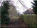
Path by Craighead, Gowrie Hill
An area with playground equipment (left centre); Craighead Road off right.
Image: © Stanley Howe
Taken: 15 Feb 2015
0.12 miles