IMAGES TAKEN NEAR TO
Golf Avenue, DUNDEE, DD5 4AS
Introduction
This page details the photographs taken nearby to Golf Avenue, DD5 4AS by members of the Geograph project.
The Geograph project started in 2005 with the aim of publishing, organising and preserving representative images for every square kilometre of Great Britain, Ireland and the Isle of Man.

There are currently over 7.5m images from over14,400 individuals and you can help contribute to the project by visiting https://www.geograph.org.uk
Image Map
Images are licensed for reuse under creativecommons.org/licenses/by-sa/2.0
Notes
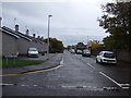
- Clicking on the map will re-center to the selected point.
- The higher the marker number, the further away the image location is from the centre of the postcode.
Image Listing (18 Images Found)
Images are licensed for reuse under creativecommons.org/licenses/by-sa/2.0
Image
Details
Distance
1
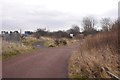
Foot / cycle path, Barry Buddon
A path follows the railway providing a link between Carnoustie and Monifieth past the Barry Buddon ranges.
Image: © Richard Webb
Taken: 12 Mar 2016
0.13 miles
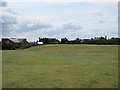
2
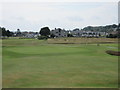
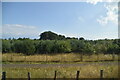
Monifieth Ashludie 7th hole, The Long Hole
The seventh hole on the Ashludie course at Monifieth from short of the green.
Image: © Scott Cormie
Taken: 23 Jul 2017
0.13 miles
3
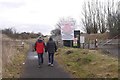
Gate, Barry Buddon Camp
The western entrance to the ranges. There is a path now passing between the railway and military land.
Image: © Richard Webb
Taken: 12 Mar 2016
0.15 miles
4
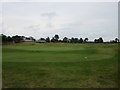
Monifieth Ashludie 18th hole, Westward Ho
The final hole on the Ashludie course at Monifieth from behind the green.
Image: © Scott Cormie
Taken: 23 Jul 2017
0.15 miles
7
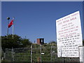
MOD land at Barry Buddon
Buddon Ness, largely MOD land guards the northern approaches to the Tay estuary. Access is limited but I'll be back to bag these squares when the red flag is down!
Image: © Val Vannet
Taken: 13 May 2005
0.16 miles
8
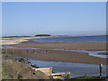
Monifieth beach
Severe erosion has reduced the beach at Monifieth from a dune system to a rock armoured shoreline in just 50 years. The view looks east to the mouth of the Buddon burn and beyond, the MOD land at Buddon Ness with the lighthouse in Image
Image: © Val Vannet
Taken: 13 May 2005
0.16 miles
9
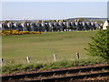
Monifieth golf course
The view looks across the Dundee to Aberdeen railway line to the start of the links course at Monifieth.
Image: © Val Vannet
Taken: 13 May 2005
0.16 miles
10
Monifieth Ashludie 13th hole, West Camp
The thirteenth hole on the Ashludie course at Monifieth looking to the elevated green in the north-west corner of the course.
Image: © Scott Cormie
Taken: 23 Jul 2017
0.17 miles