IMAGES TAKEN NEAR TO
Monikie, Broughty Ferry, DUNDEE, DD5 3QL
Introduction
This page details the photographs taken nearby to DD5 3QL by members of the Geograph project.
The Geograph project started in 2005 with the aim of publishing, organising and preserving representative images for every square kilometre of Great Britain, Ireland and the Isle of Man.

There are currently over 7.5m images from over14,400 individuals and you can help contribute to the project by visiting https://www.geograph.org.uk
Image Map
Images are licensed for reuse under creativecommons.org/licenses/by-sa/2.0
Notes
- Clicking on the map will re-center to the selected point.
- The higher the marker number, the further away the image location is from the centre of the postcode.
Image Listing (6 Images Found)
Images are licensed for reuse under creativecommons.org/licenses/by-sa/2.0
Image
Details
Distance
1
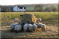
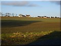
Sheep in Field
Sheep in a field near Crombie Country Park.
Image: © Mary Rodgers
Taken: 2 Jan 2019
0.06 miles
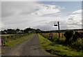
3
Wilsonhall, near Kirkton of Monikie
The view is from the B961 near Guildy looking north west to Wilsonhall past the electricity transmission line which is clearly visible on the 1:25,000 map
Image: © Val Vannet
Taken: 21 May 2005
0.16 miles
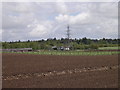
4
Crombie Country Park
The entrance to Crombie Country Park is in the extreme north east corner of the grid square.
Image: © Val Vannet
Taken: 21 May 2005
0.16 miles
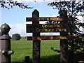
5
Guildy House
This is a new house built on the site of an old cottage. The original well is still there and is used to supply water to the garden.
Image: © Iain G Richmond
Taken: 2 Dec 2008
0.16 miles
6
Ashbank and new houses
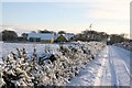
New houses built at Ashbank, Monikie. Since the Panmure Estate was sold and broken up in 2001 there have been a lot of new developments in the area.
Image: © jamesnicoll
Taken: 12 Feb 2011
0.17 miles