IMAGES TAKEN NEAR TO
Osprey Place, DUNDEE, DD5 3PS
Introduction
This page details the photographs taken nearby to Osprey Place, DD5 3PS by members of the Geograph project.
The Geograph project started in 2005 with the aim of publishing, organising and preserving representative images for every square kilometre of Great Britain, Ireland and the Isle of Man.

There are currently over 7.5m images from over14,400 individuals and you can help contribute to the project by visiting https://www.geograph.org.uk
Image Map
Images are licensed for reuse under creativecommons.org/licenses/by-sa/2.0
Notes
- Clicking on the map will re-center to the selected point.
- The higher the marker number, the further away the image location is from the centre of the postcode.
Image Listing (9 Images Found)
Images are licensed for reuse under creativecommons.org/licenses/by-sa/2.0
Image
Details
Distance
2
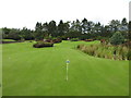
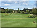
The Cairngorms Putting Green
Putting green modelled on The Cairngorms, at Forbes of Kingennie Country Resort.
Image: © Scott Cormie
Taken: 6 Sep 2019
0.08 miles
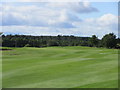
3
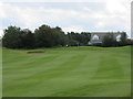
Kingennie Golf Course, 8th/17th Holes, The Strawberry Fields
The eighth hole at Kingennie, looking to the green.
Image: © Scott Cormie
Taken: 6 Sep 2019
0.12 miles
5
Kingennie Golf Course, 9th/18th Holes, The Cundie
The short final hole at Kingennie from tee to the green just beyond the pond on the right.
Image: © Scott Cormie
Taken: 6 Sep 2019
0.17 miles
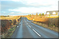
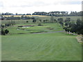
7
Kingennie Golf Course, 2nd/11th Holes, The Heights
The long second hole at Kingennie, looking to the green.
Image: © Scott Cormie
Taken: 6 Sep 2019
0.22 miles
9
Kingennie Golf Course, 7th/16th Holes, The Burn
The seventh hole at Kingennie, looking down the hill from the tee to the distant green beyond the snaking Buddon Burn.
Image: © Scott Cormie
Taken: 6 Sep 2019
0.25 miles