IMAGES TAKEN NEAR TO
North Balmossie Street, DUNDEE, DD5 2TZ
Introduction
This page details the photographs taken nearby to North Balmossie Street, DD5 2TZ by members of the Geograph project.
The Geograph project started in 2005 with the aim of publishing, organising and preserving representative images for every square kilometre of Great Britain, Ireland and the Isle of Man.

There are currently over 7.5m images from over14,400 individuals and you can help contribute to the project by visiting https://www.geograph.org.uk
Image Map
Images are licensed for reuse under creativecommons.org/licenses/by-sa/2.0
Notes
- Clicking on the map will re-center to the selected point.
- The higher the marker number, the further away the image location is from the centre of the postcode.
Image Listing (18 Images Found)
Images are licensed for reuse under creativecommons.org/licenses/by-sa/2.0
Image
Details
Distance
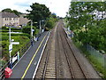
2
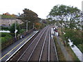
Balmossie Railway Station
East Coast Main Line towards Arbroath.
Image: © JThomas
Taken: 23 Oct 2013
0.17 miles
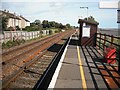
3
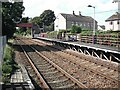
Balmossie Station
Serves Barnhill and only used at peak times.
Image: © Richard Webb
Taken: 7 Sep 2009
0.18 miles
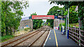
5

Balmossie railway station, Dundee
Opened in 1962 by British Rail on the line from Dundee to Arbroath.
View east towards Monifieth and Arbroath.
Image: © Nigel Thompson
Taken: 28 May 2014
0.18 miles
8
Balmossie Station
Commuter halt, used only at peak times.
Image: © Richard Webb
Taken: 7 Sep 2009
0.21 miles
9
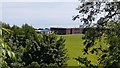
Monifieth High School
The school seen from the Seven Arches viaduct. Tentsmuir forest in Fife can just be made out across the Tay estuary.
Image: © AlastairG
Taken: 8 Jul 2014
0.21 miles
10
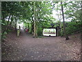
Footpath and cycle path on line of former railway
The bridge is all that remains of the railway infrastructure at this point
Image: © Douglas Nelson
Taken: 1 Jul 2015
0.22 miles