IMAGES TAKEN NEAR TO
Forthill Road, DUNDEE, DD5 2JT
Introduction
This page details the photographs taken nearby to Forthill Road, DD5 2JT by members of the Geograph project.
The Geograph project started in 2005 with the aim of publishing, organising and preserving representative images for every square kilometre of Great Britain, Ireland and the Isle of Man.

There are currently over 7.5m images from over14,400 individuals and you can help contribute to the project by visiting https://www.geograph.org.uk
Image Map (Loading...)


Getting Data...Please wait
Leaflet Map data © OpenStreetMap
Images are licensed for reuse under creativecommons.org/licenses/by-sa/2.0
Notes
- Clicking on the map will re-center to the selected point.
- The higher the marker number, the further away the image location is from the centre of the postcode.
Image Listing (20 Images Found)
Images are licensed for reuse under creativecommons.org/licenses/by-sa/2.0
Image
Details
Distance
1
Forthill Cottage
On Hill Street, Broughty Ferry.
Image: © jamesnicoll
Taken: Unknown
0.13 miles
2
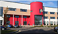
Grove Academy
The main architectural feature of the new buildings is a semicircular tower which in some ways echoes the towers of Claypotts Castle, just up the road. It is a refreshing change from the rectangular grey-white concrete block style of school building which provided so many blots on the urban landscape in the 1960s and 1970s.
Image: © Anne Burgess
Taken: 29 Jun 2011
0.19 miles
3
Limb Fitting Centre
The buildings in Bader Close were used as an auxiliary hospital during the Great War and stayed in use as a limb fitting centre.
Image: © John M
Taken: 1 Sep 2017
0.20 miles
4
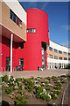
Grove Academy
The main entrance to the new building on Claypotts road is startling, certainly not dull. This was well outside school hours, and the place was busy with comings and goings of adults, presumably using the school sports facilities.
Image: © Anne Burgess
Taken: 29 Jun 2011
0.20 miles
5
Overlooking central Broughty Ferry
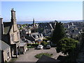
This view over the rooftops of central Broughty Ferry extends to the Firth of Tay and the wooded area of Tentsmuir Point on the Fife side of the estuary. The church spire which breaks the line of the rooftops is East Church, in NO4630
Image: © Val Vannet
Taken: 13 May 2005
0.20 miles
6
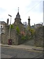
Former gatehouse
This wonderfully ornate gatehouse in Camphill Road, Broughty Ferry, was once the entrance to Carbet Castle which was demolished in 1984. It used to be owned by the Grimond family, owners of the Bowbridge jute works in Dundee.
Image: © James Allan
Taken: 25 Jan 2016
0.20 miles
7
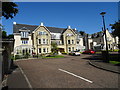
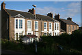
15 Camphill Road
A typical Victorian stone villa, built no doubt by a prosperous Dundee merchant, and now divided into apartments. It must have an excellent view over the Tay Estuary.
Image: © Anne Burgess
Taken: 29 Jun 2011
0.20 miles
8
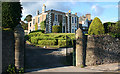
Elmbank House
This is taken from almost the same spot as Image], and provides a complete contrast. These two houses are on the Victorian 25 inch to the mile map, when there were no streets at all west of Claypotts Road. They are now surrounded on the east by the buildings of Grove Academy.
Image: © Anne Burgess
Taken: 29 Jun 2011
0.20 miles
9
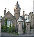
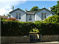
Victoriana
An elaborate lodge and a pair of ornate gate piers in Camphill Road are evidence of a wealthy businessman indulging in some conspicuous consumption in the late 19th century. This is the mark of Dundee's trading heyday which, like its counterparts in other cities, has left a legacy of interesting, if not always especially beautiful, buildings.
Image: © Anne Burgess
Taken: 29 Jun 2011
0.21 miles
10
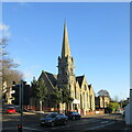
Former Queen Street Church
Church and steeple of the former Queen Street United Presbyterian Church in Broughty Ferry, now a restaurant.
Image: © Scott Cormie
Taken: 2 Jan 2022
0.21 miles