1
Hermitage Road
Steeply sloping to town centre
Image: © Jim Smillie
Taken: 29 Oct 2022
0.01 miles
2
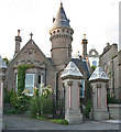
Victoriana
An elaborate lodge and a pair of ornate gate piers in Camphill Road are evidence of a wealthy businessman indulging in some conspicuous consumption in the late 19th century. This is the mark of Dundee's trading heyday which, like its counterparts in other cities, has left a legacy of interesting, if not always especially beautiful, buildings.
Image: © Anne Burgess
Taken: 29 Jun 2011
0.07 miles
3
15 Camphill Road
A typical Victorian stone villa, built no doubt by a prosperous Dundee merchant, and now divided into apartments. It must have an excellent view over the Tay Estuary.
Image: © Anne Burgess
Taken: 29 Jun 2011
0.07 miles
4
Former gatehouse
This wonderfully ornate gatehouse in Camphill Road, Broughty Ferry, was once the entrance to Carbet Castle which was demolished in 1984. It used to be owned by the Grimond family, owners of the Bowbridge jute works in Dundee.
Image: © James Allan
Taken: 25 Jan 2016
0.07 miles
5
Gray Street, Broughty Ferry
Gray Street in Broughty Ferry is named after the family who built the 15th century castle in what is now a suburb of Dundee. The street itself stretches right down to the front.
Image: © Euan Nelson
Taken: 9 May 2015
0.07 miles
6
St Vincent Street, Broughty Ferry
The dip under the bridge flooded frequently in the 1960s. Don't know if it does still.
Image: © Elliott Simpson
Taken: 1 Aug 1966
0.09 miles
7
Level Crossing at Broughty Ferry
looking towards the Tay
Image: © Glyn Baker
Taken: 6 Apr 2019
0.10 miles
8
Broughty Ferry New Kirk, East Church and hall
For details see other photograph of Broughty Ferry New Kirk, East Church. http://www.geograph.org.uk/photo/477561
Image: © Douglas Nelson
Taken: 25 Jun 2007
0.10 miles
9
Broughty Ferry New Kirk, East Church, Queen Street
Broughty Ferry New Kirk was created as a result of the Union between East Church and St Aidan's in June 2005.
The East Church building was built as a Free Church and opened in 1865. It was designed to have a spire but was never built as the congregation could not afford it.
It was once described as "the handsomest Presbyterian Church of its size that we have yet seen in Scotland."
Image: © Douglas Nelson
Taken: 25 Jun 2007
0.10 miles
10
Whinny Brae
A steep pull for horse drawn transport
Image: © Jim Smillie
Taken: 29 Oct 2022
0.10 miles


