IMAGES TAKEN NEAR TO
Oakley Place, DUNDEE, DD5 2HX
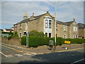
Introduction
This page details the photographs taken nearby to Oakley Place, DD5 2HX by members of the Geograph project.
The Geograph project started in 2005 with the aim of publishing, organising and preserving representative images for every square kilometre of Great Britain, Ireland and the Isle of Man.

There are currently over 7.5m images from over14,400 individuals and you can help contribute to the project by visiting https://www.geograph.org.uk
Image Map (Loading...)


Getting Data...Please wait
Leaflet Map data © OpenStreetMap
Images are licensed for reuse under creativecommons.org/licenses/by-sa/2.0
Notes
- Clicking on the map will re-center to the selected point.
- The higher the marker number, the further away the image location is from the centre of the postcode.
Image Listing (62 Images Found)
Images are licensed for reuse under creativecommons.org/licenses/by-sa/2.0
Image
Details
Distance
1
St Vincent Street, Broughty Ferry
The dip under the bridge flooded frequently in the 1960s. Don't know if it does still.
Image: © Elliott Simpson
Taken: 1 Aug 1966
0.05 miles
2
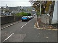
Hermitage Road
Steeply sloping to town centre
Image: © Jim Smillie
Taken: 29 Oct 2022
0.05 miles
3
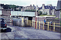
Rail bridge over St Vincent Street
Just south of the junction with Queen Street (A930) in Broughty Ferry.
Image: © Stanley Howe
Taken: 20 Aug 2013
0.07 miles
4
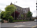
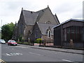
Broughty Ferry New Kirk, East Church, Queen Street
Broughty Ferry New Kirk was created as a result of the Union between East Church and St Aidan's in June 2005.
The East Church building was built as a Free Church and opened in 1865. It was designed to have a spire but was never built as the congregation could not afford it.
It was once described as "the handsomest Presbyterian Church of its size that we have yet seen in Scotland."
Image: © Douglas Nelson
Taken: 25 Jun 2007
0.07 miles
5
Broughty Ferry New Kirk, East Church and hall
For details see other photograph of Broughty Ferry New Kirk, East Church. http://www.geograph.org.uk/photo/477561
Image: © Douglas Nelson
Taken: 25 Jun 2007
0.07 miles
6
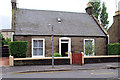
Walnut Cottage
We used to sit on the wall of this garden as children, while we were waiting on the bus back from Broughty Ferry beach. We could never figure out how the place got its name, because we couldn't see any walnuts.
Image: © william
Taken: 15 Jul 2010
0.08 miles
7
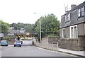
Whinny Brae
A steep pull for horse drawn transport
Image: © Jim Smillie
Taken: 29 Oct 2022
0.08 miles
9
Bella Villa
Bella Villa, Brook Street. Built by one of my mothers ancestors.
Image: © jamesnicoll
Taken: 16 Aug 2008
0.11 miles
10
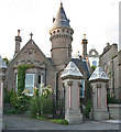
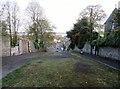
Victoriana
An elaborate lodge and a pair of ornate gate piers in Camphill Road are evidence of a wealthy businessman indulging in some conspicuous consumption in the late 19th century. This is the mark of Dundee's trading heyday which, like its counterparts in other cities, has left a legacy of interesting, if not always especially beautiful, buildings.
Image: © Anne Burgess
Taken: 29 Jun 2011
0.12 miles