IMAGES TAKEN NEAR TO
Queen Street, DUNDEE, DD5 2HT
Introduction
This page details the photographs taken nearby to Queen Street, DD5 2HT by members of the Geograph project.
The Geograph project started in 2005 with the aim of publishing, organising and preserving representative images for every square kilometre of Great Britain, Ireland and the Isle of Man.

There are currently over 7.5m images from over14,400 individuals and you can help contribute to the project by visiting https://www.geograph.org.uk
Image Map
Images are licensed for reuse under creativecommons.org/licenses/by-sa/2.0
Notes
- Clicking on the map will re-center to the selected point.
- The higher the marker number, the further away the image location is from the centre of the postcode.
Image Listing (79 Images Found)
Images are licensed for reuse under creativecommons.org/licenses/by-sa/2.0
Image
Details
Distance
1
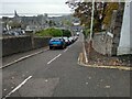
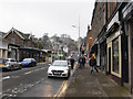
Hermitage Road
Steeply sloping to town centre
Image: © Jim Smillie
Taken: 29 Oct 2022
0.04 miles
2
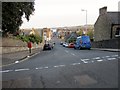
Gray Street, Broughty Ferry
Gray Street in Broughty Ferry is named after the family who built the 15th century castle in what is now a suburb of Dundee. The street itself stretches right down to the front.
Image: © Euan Nelson
Taken: 9 May 2015
0.06 miles
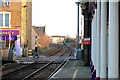
3
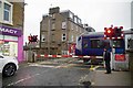
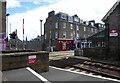
Level Crossing at Broughty Ferry
looking towards the Tay
Image: © Glyn Baker
Taken: 6 Apr 2019
0.06 miles
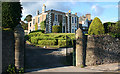
4
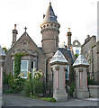
Victoriana
An elaborate lodge and a pair of ornate gate piers in Camphill Road are evidence of a wealthy businessman indulging in some conspicuous consumption in the late 19th century. This is the mark of Dundee's trading heyday which, like its counterparts in other cities, has left a legacy of interesting, if not always especially beautiful, buildings.
Image: © Anne Burgess
Taken: 29 Jun 2011
0.07 miles
5
Gray Street, Broughty Ferry
Looking towards the level crossing where the Dundee - Arbroath railway line crosses Gray Street.
Image: © Stephen McKay
Taken: 6 Apr 2019
0.07 miles
6
Level crossing at Broughty Ferry station
On the Dundee and Arbroath line which was an early railway in Scotland. It opened in 1838, and used the unusual track gauge of 5 ft 6 in (1,676 mm). In 1848 it changed to standard gauge and connected to the emerging Scottish railway network.
Image: © Russel Wills
Taken: 14 Jun 2021
0.07 miles
7
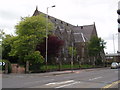
Broughty Ferry New Kirk, East Church, Queen Street
Broughty Ferry New Kirk was created as a result of the Union between East Church and St Aidan's in June 2005.
The East Church building was built as a Free Church and opened in 1865. It was designed to have a spire but was never built as the congregation could not afford it.
It was once described as "the handsomest Presbyterian Church of its size that we have yet seen in Scotland."
Image: © Douglas Nelson
Taken: 25 Jun 2007
0.08 miles
8
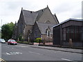
Broughty Ferry New Kirk, East Church and hall
For details see other photograph of Broughty Ferry New Kirk, East Church. http://www.geograph.org.uk/photo/477561
Image: © Douglas Nelson
Taken: 25 Jun 2007
0.08 miles
9
Level crossing at Broughty Ferry
Where the main east coast railway line crosses Gray Street Broughty Ferry
Image: © Paul McIlroy
Taken: 30 Dec 2008
0.08 miles
10
15 Camphill Road
A typical Victorian stone villa, built no doubt by a prosperous Dundee merchant, and now divided into apartments. It must have an excellent view over the Tay Estuary.
Image: © Anne Burgess
Taken: 29 Jun 2011
0.08 miles