IMAGES TAKEN NEAR TO
Long Lane, DUNDEE, DD5 1HF
Introduction
This page details the photographs taken nearby to Long Lane, DD5 1HF by members of the Geograph project.
The Geograph project started in 2005 with the aim of publishing, organising and preserving representative images for every square kilometre of Great Britain, Ireland and the Isle of Man.

There are currently over 7.5m images from over14,400 individuals and you can help contribute to the project by visiting https://www.geograph.org.uk
Image Map
Images are licensed for reuse under creativecommons.org/licenses/by-sa/2.0
Notes
- Clicking on the map will re-center to the selected point.
- The higher the marker number, the further away the image location is from the centre of the postcode.
Image Listing (112 Images Found)
Images are licensed for reuse under creativecommons.org/licenses/by-sa/2.0
Image
Details
Distance
1
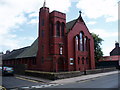
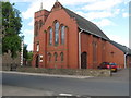
Our Lady of Good Counsel
Situated in Westfield Road,Broughty Ferry.
Image: © Douglas Nelson
Taken: 11 Jul 2007
0.02 miles
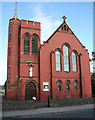
2
Our Lady of Good Counsel Catholic Church
The red brick Catholic church in Broughty Ferry from across Westfield Road.
Image: © Scott Cormie
Taken: 24 Mar 2017
0.03 miles
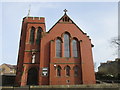
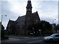
3
Our Lady of Good Counsel
Broughty Ferry seems to have had a veritable plethora of churches of various denominations, many no longer in use as such. This Roman Catholic one, originally known as St Joseph's, is still in use. Designed in Gothic style by Thomas Martin Cappon, it celebrated its centenary in 2004. The original church has been opened out to make a social space and church services are now held in a later extension to the south.
Image: © Anne Burgess
Taken: 29 Jun 2011
0.03 miles
4
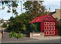
Garage in Westfield Road
An interestingly different garage, with smart paintwork and a weather vane in the shape of a ship on its gable. To its left is the car park of Image] next door.
Image: © Anne Burgess
Taken: 29 Jun 2011
0.04 miles
5
Our Lady of Good Counsel Roman Catholic Church
In Westfield Road, West Ferry, Dundee.
Image: © James Denham
Taken: 2 Jun 2010
0.04 miles
6
St Stephen's and West, Broughty Ferry
Image: © Douglas Nelson
Taken: 12 Jul 2007
0.05 miles
7
After the lightning strike
A lightning bolt hit the spire of St Stephen's and West Church in Broughty Ferry on the afternoon of Thursday 27th May 2010. The spire has been assessed as safe but it will require complete rebuilding.
Image: © jamesnicoll
Taken: 3 Jun 2010
0.06 miles
8
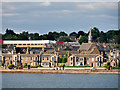
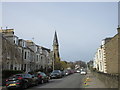
Broughty Ferry
Broughty (Brochtie) Ferry is a suburb of Dundee situated four miles east of the city centre on the north bank of the Firth of Tay. Formerly a prosperous fishing and whaling village, the area was a separate burgh from 1864 until 1913, when it was incorporated into Dundee (https://en.wikipedia.org/wiki/Broughty_Ferry Wikipedia).
In this photograph, the prominent landmark is the spire of St Stephen's Church behind the waterfront.
Image: © David Dixon
Taken: 8 Jul 2016
0.06 miles
9
St.Stephen`s and West Church
The rebuilt spire of St.Stephen`s from the foot of Westfield Road.
Image: © Scott Cormie
Taken: 24 Mar 2017
0.07 miles
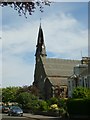
10
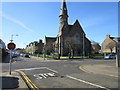
St. Stephen's and West Church, Broughty Ferry
The church of St. Stephen's and West dates to 1871 and was designed by the architect, Thomas S. Robertson (1835-1923).
Image: © Euan Nelson
Taken: 5 Apr 2015
0.07 miles