IMAGES TAKEN NEAR TO
Queen Street, DUNDEE, DD5 1AF
Introduction
This page details the photographs taken nearby to Queen Street, DD5 1AF by members of the Geograph project.
The Geograph project started in 2005 with the aim of publishing, organising and preserving representative images for every square kilometre of Great Britain, Ireland and the Isle of Man.

There are currently over 7.5m images from over14,400 individuals and you can help contribute to the project by visiting https://www.geograph.org.uk
Image Map
Images are licensed for reuse under creativecommons.org/licenses/by-sa/2.0
Notes
- Clicking on the map will re-center to the selected point.
- The higher the marker number, the further away the image location is from the centre of the postcode.
Image Listing (62 Images Found)
Images are licensed for reuse under creativecommons.org/licenses/by-sa/2.0
Image
Details
Distance
1
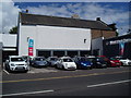
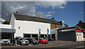
Former Drill Hall
Originally built as a drill hall, this was a cinema for a time and is now part of a garage business.
Image: © Anne Burgess
Taken: 7 Aug 2014
0.05 miles
2
Former Drill Hall in Broughty Ferry
This building at 51 Queen Street was the former Regal Cinema in Broughty Ferry. It was built around 1870 as a drill hall for the 1st Forfarshire Artillery Volunteers, formed in 1860 to garrison Broughty Ferry Castle. They were the original Territorial RGA unit stationed at the Castle at the outbreak of the Great War. It is now a car dealership.
Image: © Douglas Nelson
Taken: 5 Jul 2014
0.05 miles
3
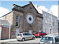
Former Drill Hall in Broughty Ferry
This building at 51 Queen Street (this view taken in Church Street ) was the former Regal Cinema in Broughty Ferry. It was built around 1870 as a drill hall for the 1st Forfarshire Artillery Volunteers, formed in 1860 to garrison Broughty Ferry Castle. They were the original Territorial RGA unit stationed at the Castle at the outbreak of the Great War. See Image
Image: © Douglas Nelson
Taken: 5 Jul 2014
0.05 miles
4
West End Garage
The white building is what was originally a drill hall.
Image: © Anne Burgess
Taken: 7 Aug 2014
0.05 miles
5
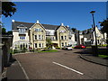
Limb Fitting Centre
The buildings in Bader Close were used as an auxiliary hospital during the Great War and stayed in use as a limb fitting centre.
Image: © John M
Taken: 1 Sep 2017
0.05 miles
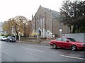
6
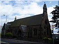
St Mary's Episcopal Church, Broughty Ferry.
Image: © Douglas Nelson
Taken: 11 Jul 2007
0.07 miles
7
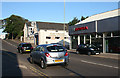
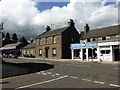
Queen Street
Queen Street is part of what is now the A930, a road built, presumably, to take through traffic out of the centre of Broughty Ferry. It has its share of commercial premises too; this view includes a chartered accountant and a car dealer.
Image: © Anne Burgess
Taken: 29 Jun 2011
0.07 miles
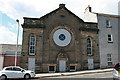
8
Former Congregational Church, Broughty Ferry
The building's use has been converted into offices.
Image: © Douglas Nelson
Taken: 9 Nov 2012
0.09 miles
9
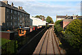
Railway Line at Broughty Ferry
Looking east, towards Carnoustie and Arbroath from the overbridge which carried Westfield Road. On the left are the backs of the tenements on Queen Street, the A930, seen in Image
Image: © Anne Burgess
Taken: 29 Jun 2011
0.10 miles