IMAGES TAKEN NEAR TO
Princes Street, DUNDEE, DD4 6DQ
Introduction
This page details the photographs taken nearby to Princes Street, DD4 6DQ by members of the Geograph project.
The Geograph project started in 2005 with the aim of publishing, organising and preserving representative images for every square kilometre of Great Britain, Ireland and the Isle of Man.

There are currently over 7.5m images from over14,400 individuals and you can help contribute to the project by visiting https://www.geograph.org.uk
Image Map
Images are licensed for reuse under creativecommons.org/licenses/by-sa/2.0
Notes
- Clicking on the map will re-center to the selected point.
- The higher the marker number, the further away the image location is from the centre of the postcode.
Image Listing (60 Images Found)
Images are licensed for reuse under creativecommons.org/licenses/by-sa/2.0
Image
Details
Distance
1
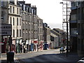
Down Albert Street
Looking downhill from the road junction with Victoria Street to the right and Arbroath Road to the left, the tenement flats and shops showing the steep drop in level down towards the city centre. The Kingdom of Fife is visible as a grey wash in the background, separated by the silv'ry Tay.
Image: © Ian Paterson
Taken: 1 Nov 2011
0.01 miles
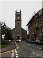
2
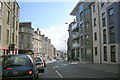
Albert Street, Dundee, at its junction with Princes Street, Arbroath Road and Victoria Street
Picture taken from Albert Street. Princes Street is straight ahead, with Arbroath Road to the left and Victoria Street to the right.
Image: © Alan Morrison
Taken: 1 Mar 2009
0.01 miles
3
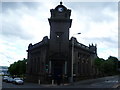
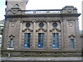
Dundee Savings Bank, corner of Victoria Street and Albert Street
Image: © kim traynor
Taken: 22 May 2011
0.02 miles
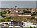
7
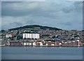
Dundee
This view of the city over the Firth of Tay was taken from a layby on the B946. The wooded hill in the background is Dundee Law.
Image: © Walter Baxter
Taken: 16 Jul 2013
0.07 miles
8
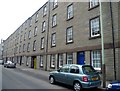
Lyon Street tenement
A terrace built in 1886-7 for the workers of the Dens Mills. According to the listed buildings record, Baxter Brothers, Dundee's biggest employers at the time, were the only textile company to build housing for their workers in the centre of the city. In 1871, this block housed 648 people in 30 two-room, 73 three-room and 1 four-roomed houses at a cost of £11,892. They were renovated in the early 1980s.
Image: © kim traynor
Taken: 22 May 2011
0.08 miles
9
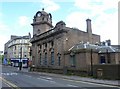
Trinity Parish Church, Dundee
Trinity Parish Church is so named because of the joining of three churches - Wallacetown, St. Matthews and Baxter Park. The congregation came together in Wallacetown Church and St. Matthews and Baxter Park churches were demolished
Image: © Douglas Nelson
Taken: 23 Aug 2013
0.08 miles
10
Dundee, Halley?s Jute Mill (Wallace Craigie Works)
Built in 1835, Halley’s Mill (Wallace Craigie Works) was once a prestigious icon of the Dundee’s world-leading jute industry. At its height in the late 19th century, Dundee boasted around 60 jute mills and more than 50,000 workers were employed by Dundee’s jute industry, leading to the city being branded as ‘Juteopolis’. As one of the biggest mills in the city, Halley’s employed hundreds of people and outran many of its competitors to become the last working, independently-owned mill in the city. William Halley and Sons Ltd continued as a family firm based at Wallace Craigie Works until its closure in 2004, since which time the complex has been vacant. The building currently looks very dilapidated and it is on the Historic Scotland Buildings at Risk Register (HS Reference No 25132 http://www.buildingsatrisk.org.uk/details/912065) but plans have been put forward to transform it into 175 modern apartments (http://dundee.stv.tv/articles/299126-halleys-jute-mill-wallace-craigie-works-redeveloped-into-100-flats/ STV) which will save the Mill facade, including the instantly recognisable gold lettering on red brick. It is a Category B listed building (LB25132 http://portal.historicenvironment.scot/designation/LB25132 Historic Scotland).
Image: © David Dixon
Taken: 8 Jul 2016
0.09 miles