IMAGES TAKEN NEAR TO
Muirfield Place, DUNDEE, DD3 8PR
Introduction
This page details the photographs taken nearby to Muirfield Place, DD3 8PR by members of the Geograph project.
The Geograph project started in 2005 with the aim of publishing, organising and preserving representative images for every square kilometre of Great Britain, Ireland and the Isle of Man.

There are currently over 7.5m images from over14,400 individuals and you can help contribute to the project by visiting https://www.geograph.org.uk
Image Map
Images are licensed for reuse under creativecommons.org/licenses/by-sa/2.0
Notes
- Clicking on the map will re-center to the selected point.
- The higher the marker number, the further away the image location is from the centre of the postcode.
Image Listing (15 Images Found)
Images are licensed for reuse under creativecommons.org/licenses/by-sa/2.0
Image
Details
Distance
3
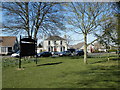
Former farmhouse opposite Fairmuir Park
Image: © Douglas Nelson
Taken: 18 Apr 2015
0.08 miles
4
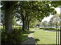
Site of former rail line at Fairmuir Park
The line continued here from nearby Fairmuir Station to Maryfield.
Image: © Douglas Nelson
Taken: 10 May 2016
0.16 miles
5
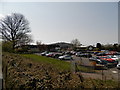
Site of former railway goods station
This section of the former Fairmuir Railway Goods Station is a car park for employees of Tayside Contracts.
Image: © Douglas Nelson
Taken: 10 May 2016
0.18 miles
6

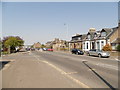
North side of Clepington Road, Dundee
The castellated building is something to do with the water supply
Image: © Elliott Simpson
Taken: 12 May 2009
0.19 miles
7
Western end of Clepington Road, Dundee
The "wee castle" in the middle ground is part of the public water supply infrastructure.
Image: © Douglas Nelson
Taken: 10 May 2016
0.19 miles
8

Outbreak of bright on The Kingsway
The photographer is shooting into the southerly bright to capture an atmospheric effect over The Kingsway in Dundee.
Image: © C Michael Hogan
Taken: 8 Jul 2012
0.21 miles
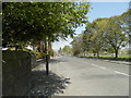
9
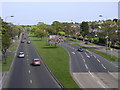
The Kingsway
The Kingsway was built in the late 1920s as a bypass for the city. It must rank as one of the best bits of forward town planning in any Scottish city! Although today it is well within the boundary of the city and it forms part of the A90T, it channels through-traffic well away from the city centre.
Image: © Val Vannet
Taken: 14 May 2005
0.21 miles
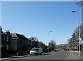
10
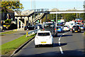
Pedestrian Bridge over Kingsway at Strathmartine Rd Junction
Image: © David Dixon
Taken: 24 Sep 2018
0.22 miles