IMAGES TAKEN NEAR TO
Strathmartine, DUNDEE, DD3 0PA
Introduction
This page details the photographs taken nearby to DD3 0PA by members of the Geograph project.
The Geograph project started in 2005 with the aim of publishing, organising and preserving representative images for every square kilometre of Great Britain, Ireland and the Isle of Man.

There are currently over 7.5m images from over14,400 individuals and you can help contribute to the project by visiting https://www.geograph.org.uk
Image Map
Images are licensed for reuse under creativecommons.org/licenses/by-sa/2.0
Notes
- Clicking on the map will re-center to the selected point.
- The higher the marker number, the further away the image location is from the centre of the postcode.
Image Listing (6 Images Found)
Images are licensed for reuse under creativecommons.org/licenses/by-sa/2.0
Image
Details
Distance
5
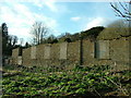
Baldovan House
Baldovan House pre 1820s was destroyed by the council
Image: © stephen samson
Taken: 19 Apr 2008
0.19 miles
6
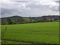
Farmland to the north of Dundee
The skyline of Dundee is here viewed looking south south west from the minor road in the east of the grid square. Dundee Law (Image) stands out clearly on the skyline while the chimney known as Cox's Stack (grid square Image) breaks the skyline to the right of the photo.
Image: © Val Vannet
Taken: 23 May 2005
0.22 miles