IMAGES TAKEN NEAR TO
Newtyle Road, DUNDEE, DD2 5QP
Introduction
This page details the photographs taken nearby to Newtyle Road, DD2 5QP by members of the Geograph project.
The Geograph project started in 2005 with the aim of publishing, organising and preserving representative images for every square kilometre of Great Britain, Ireland and the Isle of Man.

There are currently over 7.5m images from over14,400 individuals and you can help contribute to the project by visiting https://www.geograph.org.uk
Image Map
Images are licensed for reuse under creativecommons.org/licenses/by-sa/2.0
Notes
- Clicking on the map will re-center to the selected point.
- The higher the marker number, the further away the image location is from the centre of the postcode.
Image Listing (6 Images Found)
Images are licensed for reuse under creativecommons.org/licenses/by-sa/2.0
Image
Details
Distance
1

Muirhead Church
The church was built following The Disruption of 1843. Local stone was used and transported by local farmers. The church is linked to St Marnock's Church, Fowlis Easter, Liff Church and Lundie Church.
Image: © Douglas Nelson
Taken: 22 Mar 2016
0.08 miles
2

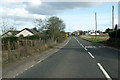
Heading in to Muirhead
The A923 heading to Dundee.
Image: © James Denham
Taken: 4 Jun 2010
0.11 miles
3

View north from Muirhead
Looking towards the masts on Craigowl Hill.
Image: © Mike Pennington
Taken: 30 Dec 2009
0.14 miles
4
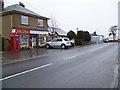
Village shops, Muirhead
Post office and chemist beside the A923 in Muirhead. Outside of the post office is a K6 type telephone box.
In 1935, the Post Office commissioned a new kiosk from Sir Giles Gilbert Scott to celebrate the Jubilee of King George V. The K6 Jubilee Kiosk, as it is known, was similar to the K2 box, being made of cast iron and painted red but was 25% lighter in weight. By the end of the 1930s there were 20,000 K6 telephone boxes in use all over the UK.
Image: © Maigheach-gheal
Taken: 30 Mar 2010
0.16 miles
6
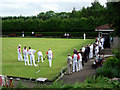
Muirhead and Birkhill bowling club
The bowling club is in the south east corner of the grid box and can be seen to the south of the main road on the 1:25,000 map.
Image: © Val Vannet
Taken: 18 Jun 2005
0.22 miles