IMAGES TAKEN NEAR TO
Tayview Drive, DUNDEE, DD2 5PF
Introduction
This page details the photographs taken nearby to Tayview Drive, DD2 5PF by members of the Geograph project.
The Geograph project started in 2005 with the aim of publishing, organising and preserving representative images for every square kilometre of Great Britain, Ireland and the Isle of Man.

There are currently over 7.5m images from over14,400 individuals and you can help contribute to the project by visiting https://www.geograph.org.uk
Image Map
Images are licensed for reuse under creativecommons.org/licenses/by-sa/2.0
Notes
- Clicking on the map will re-center to the selected point.
- The higher the marker number, the further away the image location is from the centre of the postcode.
Image Listing (6 Images Found)
Images are licensed for reuse under creativecommons.org/licenses/by-sa/2.0
Image
Details
Distance
1
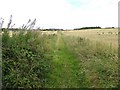
Path, Stonygroves
On the map it looks like a driveway, but is actually a singletrack green lane.
Image: © Richard Webb
Taken: 30 Aug 2014
0.15 miles
2
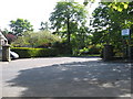
Royal Dundee Liff Hospital
The main entrance.
Image: © James Denham
Taken: 31 May 2010
0.15 miles
3
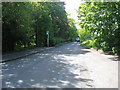
Leafy road near Liff Hospital
North of Dundee.
Image: © James Denham
Taken: 31 May 2010
0.17 miles
4
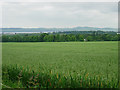
Oatfield near Mains of Gray
The view is taken from the minor road in the south west corner of the grid box and looks south west to the deciduous woodland surrounding Mains of Gray house and beyond, to the Tay estuary and the north of Fife.
Image: © Val Vannet
Taken: 18 Jun 2005
0.21 miles
5
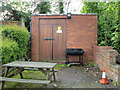
Electricity Substation No 3432 - Main Street
Image: © Betty Longbottom
Taken: 12 May 2014
0.21 miles
6
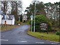
Entrance to West Green Park
The buildings in the background previously formed part of Liff Psychiatric Hospital but most are now in use as residential properties.
Image: © James Allan
Taken: 2 Dec 2013
0.25 miles