IMAGES TAKEN NEAR TO
Wade Street, DUNDEE, DD2 4SN
Introduction
This page details the photographs taken nearby to Wade Street, DD2 4SN by members of the Geograph project.
The Geograph project started in 2005 with the aim of publishing, organising and preserving representative images for every square kilometre of Great Britain, Ireland and the Isle of Man.

There are currently over 7.5m images from over14,400 individuals and you can help contribute to the project by visiting https://www.geograph.org.uk
Image Map
Images are licensed for reuse under creativecommons.org/licenses/by-sa/2.0
Notes
- Clicking on the map will re-center to the selected point.
- The higher the marker number, the further away the image location is from the centre of the postcode.
Image Listing (6 Images Found)
Images are licensed for reuse under creativecommons.org/licenses/by-sa/2.0
Image
Details
Distance
1
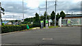
Factory to let
Vacant industrial premises (= more folk on the broo) at Wester Gourdie Industrial Estate.
Image: © Richard Webb
Taken: 16 May 2010
0.13 miles
2
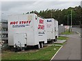
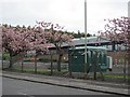
Snack trailers
Cyclists like industrial estates - always a brew to be had in work hours. Trailers parked up on a Sunday morning, Wester Gourdie Industrial Estate.
Image: © Richard Webb
Taken: 16 May 2010
0.14 miles
3
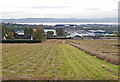
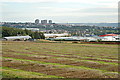
Wester Gourdie Industrial Estate
From the Liff road looking down across the crop research station and industrial estate to the Tay and Fife
Image: © Jim Bain
Taken: 6 Oct 2008
0.17 miles
4
Gourdie
Gourdie Crop Research Station with the Charleston and Menzieshill districts on the wester edge of Dundee in the background.
Image: © Jim Bain
Taken: 6 Oct 2008
0.19 miles