IMAGES TAKEN NEAR TO
Balgarthno Terrace, DUNDEE, DD2 4RD
Introduction
This page details the photographs taken nearby to Balgarthno Terrace, DD2 4RD by members of the Geograph project.
The Geograph project started in 2005 with the aim of publishing, organising and preserving representative images for every square kilometre of Great Britain, Ireland and the Isle of Man.

There are currently over 7.5m images from over14,400 individuals and you can help contribute to the project by visiting https://www.geograph.org.uk
Image Map
Images are licensed for reuse under creativecommons.org/licenses/by-sa/2.0
Notes
- Clicking on the map will re-center to the selected point.
- The higher the marker number, the further away the image location is from the centre of the postcode.
Image Listing (6 Images Found)
Images are licensed for reuse under creativecommons.org/licenses/by-sa/2.0
Image
Details
Distance
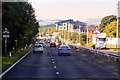
2
Kingsway
The A90 runs through northern Dundee, often very slowly. No motorways around cities here.
Image: © Richard Webb
Taken: 30 Aug 2014
0.08 miles
3
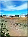
Glow Insulation
Factory on Whittle Place.
Image: © Richard Webb
Taken: 30 Aug 2014
0.16 miles
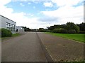
5
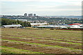
Gourdie
Gourdie Crop Research Station with the Charleston and Menzieshill districts on the wester edge of Dundee in the background.
Image: © Jim Bain
Taken: 6 Oct 2008
0.21 miles