IMAGES TAKEN NEAR TO
Sutherland Place, DUNDEE, DD2 2HG
Introduction
This page details the photographs taken nearby to Sutherland Place, DD2 2HG by members of the Geograph project.
The Geograph project started in 2005 with the aim of publishing, organising and preserving representative images for every square kilometre of Great Britain, Ireland and the Isle of Man.

There are currently over 7.5m images from over14,400 individuals and you can help contribute to the project by visiting https://www.geograph.org.uk
Image Map
Images are licensed for reuse under creativecommons.org/licenses/by-sa/2.0
Notes
- Clicking on the map will re-center to the selected point.
- The higher the marker number, the further away the image location is from the centre of the postcode.
Image Listing (11 Images Found)
Images are licensed for reuse under creativecommons.org/licenses/by-sa/2.0
Image
Details
Distance
1
Ancrum Road
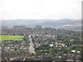
Like the Tay Road Bridge, Ancrum Road appears aligned to Dundee Law. View westward from The Law.
Image: © Richard Webb
Taken: 21 Aug 2009
0.14 miles
2
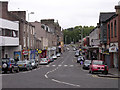
Lochee High Street
For many years a separate town, Lochee developed during the 18th Century in association with handloom weaving and in the 19th century as a centre of spinning, bleaching, dyeing and linen manufacture. By the late 19th century, many of the linen mills were producing jute.
Image: © Val Vannet
Taken: 16 May 2005
0.17 miles
3
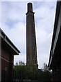
Cox's Stack
The Camperdown Works of Messrs Cox Brothers, built in 1849-64, was said to be the largest jute factory in the world with 820 powerlooms, 150 handlooms and 5000 employees. Cox's Stack, the 86-m (282-foot) high campanile-style factory chimney, survives.
Image: © Val Vannet
Taken: 16 May 2005
0.17 miles
5
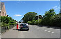
South Road, Dundee
Showing position of Postbox No. DD2 138.
See Image] for postbox.
Image: © JThomas
Taken: 12 Jun 2021
0.23 miles
6

Dundee and Newtyle Railway
A later addition to the railway. Originally trains were hauled up to a tunnel under Dundee Law by stationary steam engines. Later a long gentler climb was provided by a western deviation. The gradient still is fierce for a railway and the trackbed here is now a path.
Image: © Richard Webb
Taken: 30 Aug 2014
0.23 miles

8
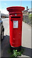
Elizabethan postbox on South Road, Dundee
Postbox No. DD2 138.
See Image] for context.
Image: © JThomas
Taken: 12 Jun 2021
0.24 miles
9
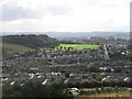
Lochee Park
The wooded Balgay Hill, Lochee Park and Ancrum Road seen from Dundee Law.
Image: © Richard Webb
Taken: 21 Aug 2009
0.24 miles
10
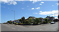
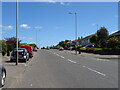
Junction of Charleston Drive and Elmwood Road, Dundee
Image: © JThomas
Taken: 12 Jun 2021
0.24 miles