IMAGES TAKEN NEAR TO
Riverside Place, DUNDEE, DD2 1QE
Introduction
This page details the photographs taken nearby to Riverside Place, DD2 1QE by members of the Geograph project.
The Geograph project started in 2005 with the aim of publishing, organising and preserving representative images for every square kilometre of Great Britain, Ireland and the Isle of Man.

There are currently over 7.5m images from over14,400 individuals and you can help contribute to the project by visiting https://www.geograph.org.uk
Image Map
Images are licensed for reuse under creativecommons.org/licenses/by-sa/2.0
Notes
- Clicking on the map will re-center to the selected point.
- The higher the marker number, the further away the image location is from the centre of the postcode.
Image Listing (6 Images Found)
Images are licensed for reuse under creativecommons.org/licenses/by-sa/2.0
Image
Details
Distance
1
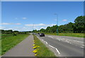
National Cycle Route 77, Ninewells
Towards Invergowrie.
Image: © JThomas
Taken: 12 Jun 2021
0.08 miles
2
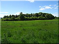
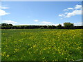
Woodland, Ninewells
With grazing near Dundee Airport.
Image: © JThomas
Taken: 12 Jun 2021
0.13 miles
3
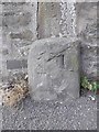
Old Milestone by Perth Road, Dundee parish
Stone post by the UC road, in parish of Dundee (City of Dundee District), Perth Road, in pavement by stone wall opposite River Crescent.
Surveyed
Milestone Society National ID: CD_DDPT02
Image: © Milestone Society
Taken: Unknown
0.15 miles
4
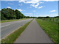
National Cycle Route 77 towards Dundee
Beside the A85.
Image: © JThomas
Taken: 12 Jun 2021
0.17 miles
6
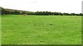
Riverside Landfill Site
An unnatural looking hill beside the Tay, and it turned out to be a reclaimed bit of tip with Highland cattle. A digger was at work covering up more of the landfill site with topsoil .
Image: © Richard Webb
Taken: 25 Aug 2010
0.25 miles