IMAGES TAKEN NEAR TO
ARBROATH, DD11 4RP
Introduction
This page details the photographs taken nearby to DD11 4RP by members of the Geograph project.
The Geograph project started in 2005 with the aim of publishing, organising and preserving representative images for every square kilometre of Great Britain, Ireland and the Isle of Man.

There are currently over 7.5m images from over14,400 individuals and you can help contribute to the project by visiting https://www.geograph.org.uk
Image Map
Images are licensed for reuse under creativecommons.org/licenses/by-sa/2.0
Notes
- Clicking on the map will re-center to the selected point.
- The higher the marker number, the further away the image location is from the centre of the postcode.
Image Listing (8 Images Found)
Images are licensed for reuse under creativecommons.org/licenses/by-sa/2.0
Image
Details
Distance
1
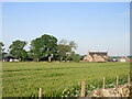
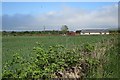
Leys of Boysack
Leys of Boysack viewed from the road to the east.
Image: © Scott Cormie
Taken: 29 May 2020
0.00 miles
2
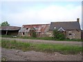
Stacks of Potential!!!!
This is a cottage on Leys of Boysack Farm Near Leysmill. It is for sale but it needs a total refurb.
http://www.vebra.com/home/search/vdetails.asp?src=agent&fd=203&bd=0&db=1&cl=165&pid=10407176
Image: © Dominic Dawn Harry and Jacob Paterson
Taken: 7 Jun 2006
0.01 miles
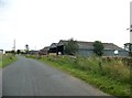
5
House near Leys of Boysack
The low white house is on the north side of the road that passes Leys of Boysack.
Image: © Anne Burgess
Taken: 3 Jun 2017
0.05 miles
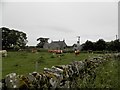
6
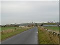
Leys of Boysack
The road east of Leysmill.
Image: © Richard Webb
Taken: 11 Nov 2015
0.11 miles
7
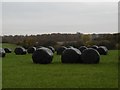
Round bales, Leys of Boysack
Silage bales still in the field. The trackbed of the Arbroath and Forfar Railway is in the background, south of the site of Leysmill Station.
Image: © Richard Webb
Taken: 11 Nov 2015
0.22 miles
8
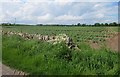
Tatties at Templeton
There seem to be a lot of tatties growing around here this year. I think the dyke shown on the map has disappeared, and the power lines have appeared, as they're not on the map.
Image: © Anne Burgess
Taken: 3 Jun 2017
0.23 miles