IMAGES TAKEN NEAR TO
ARBROATH, DD11 4QQ
Introduction
This page details the photographs taken nearby to DD11 4QQ by members of the Geograph project.
The Geograph project started in 2005 with the aim of publishing, organising and preserving representative images for every square kilometre of Great Britain, Ireland and the Isle of Man.

There are currently over 7.5m images from over14,400 individuals and you can help contribute to the project by visiting https://www.geograph.org.uk
Image Map
Images are licensed for reuse under creativecommons.org/licenses/by-sa/2.0
Notes
- Clicking on the map will re-center to the selected point.
- The higher the marker number, the further away the image location is from the centre of the postcode.
Image Listing (7 Images Found)
Images are licensed for reuse under creativecommons.org/licenses/by-sa/2.0
Image
Details
Distance
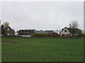
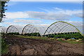
2
Naked polytunnels
Uncovered polytunnels near Garrison Farm.
Image: © Scott Cormie
Taken: 2 Jun 2020
0.06 miles
3
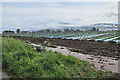
Strawberries at Garrison Farm
I wonder how these young strawberry plants, without protection against the downpour of the last 36 hours, have fared? Note the muddy puddles at the edge of the field. No doubt it won't be long now before the plastic covering is spread over the polytunnel frames.
Image: © Anne Burgess
Taken: 7 Jun 2017
0.13 miles
4
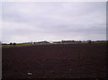
Ploughed Field With RM Condor in the Background
Image: © Dominic Dawn Harry and Jacob Paterson
Taken: 25 Jan 2006
0.16 miles
5
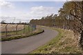
Passing RM Condor
Perimeter fencing by Garrison Farm.
Image: © Richard Webb
Taken: 25 Mar 2016
0.20 miles
6
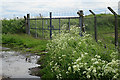
Airfield Gate
This is rather like the elephant in the room that everyone ignores. Most of this square is occupied by HMS Condor, shown on the maps as a disused airfield but still very much active Ministry of Defence property. From this back road there are glimpses of the buildings and facilities, including a rather gently inclined artificial ski slope, but most of the square is inaccessible. However this gate is firmly in square and right next the road, so provides a suitable subject to be geographed. I used to come here occasionally when the Angus Gliding Club operated here, and could have had lots of photographs if I had anticipated the advent of Geograph!
Image: © Anne Burgess
Taken: 7 Jun 2017
0.22 miles
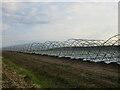
7
Polytunnels
Strawberries, protected by plastic from the sort of rain we have just been subjected to over the last two days.
Image: © Anne Burgess
Taken: 7 Jun 2017
0.22 miles