IMAGES TAKEN NEAR TO
ARBROATH, DD11 4PT
Introduction
This page details the photographs taken nearby to DD11 4PT by members of the Geograph project.
The Geograph project started in 2005 with the aim of publishing, organising and preserving representative images for every square kilometre of Great Britain, Ireland and the Isle of Man.

There are currently over 7.5m images from over14,400 individuals and you can help contribute to the project by visiting https://www.geograph.org.uk
Image Map
Images are licensed for reuse under creativecommons.org/licenses/by-sa/2.0
Notes
- Clicking on the map will re-center to the selected point.
- The higher the marker number, the further away the image location is from the centre of the postcode.
Image Listing (6 Images Found)
Images are licensed for reuse under creativecommons.org/licenses/by-sa/2.0
Image
Details
Distance
1
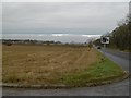
A933
Speed camera warning at Denmark's road end.
Image: © Richard Webb
Taken: 11 Nov 2015
0.09 miles
2
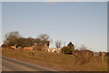
House close to the road with woodland
Image: © Gwen and James Anderson
Taken: 6 Mar 2006
0.12 miles
4
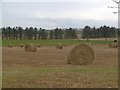
Denmark
Mixed farming with cattle grazing beyond the round straw bales.
Image: © Richard Webb
Taken: 11 Nov 2015
0.14 miles
5
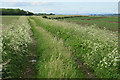
Old Track to Newton of Boysack
The height of the grass shows that this track is no longer in use. I bet my satnav doesn't know that, though!
Image: © Anne Burgess
Taken: 7 Jun 2017
0.20 miles
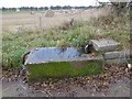
6
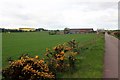
Denmark
A large farmstead off the A933 near Leysmill
Image: © Graham Hogg
Taken: 15 May 2014
0.23 miles