IMAGES TAKEN NEAR TO
Colliston, ARBROATH, DD11 3SG
Introduction
This page details the photographs taken nearby to DD11 3SG by members of the Geograph project.
The Geograph project started in 2005 with the aim of publishing, organising and preserving representative images for every square kilometre of Great Britain, Ireland and the Isle of Man.

There are currently over 7.5m images from over14,400 individuals and you can help contribute to the project by visiting https://www.geograph.org.uk
Image Map
Images are licensed for reuse under creativecommons.org/licenses/by-sa/2.0
Notes
- Clicking on the map will re-center to the selected point.
- The higher the marker number, the further away the image location is from the centre of the postcode.
Image Listing (7 Images Found)
Images are licensed for reuse under creativecommons.org/licenses/by-sa/2.0
Image
Details
Distance
1
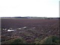
Soggy Field Near Firth Muir of Boysack
Cairnconon Hill in the distance
Image: © Dominic Dawn Harry and Jacob Paterson
Taken: 9 Dec 2006
0.15 miles
2
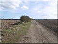
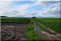
Firth Muir of Boysack
A track with recently ploughed fields by Arbroath.
Image: © Richard Webb
Taken: 25 Mar 2016
0.19 miles
3
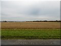
Firth Muir of Boysack
Barley stubble. In this arable area some of the hedges have gone.
Image: © Richard Webb
Taken: 11 Nov 2015
0.22 miles
4
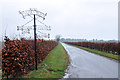
Elaborate sign for Swirlburn and surrounding farms
Image: © Steven Brown
Taken: 20 Nov 2012
0.23 miles
5
Firth Muir of Boysack
The track crosses the Firth Muir and continues to Swirlburn. The roof at top left is at Boysackhill.
Image: © Anne Burgess
Taken: 7 Jun 2017
0.24 miles
6
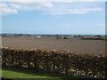
Boysackhill
Across the road from Image - a sea view from above Arbroath.
Image: © Richard Webb
Taken: 25 Mar 2016
0.24 miles
7
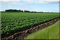
Firth Muir
Tattie fields near Firthmuir. The trees on the skyline conceal Berryhill, which is in the next square.
Image: © Anne Burgess
Taken: 7 Jun 2017
0.25 miles