IMAGES TAKEN NEAR TO
MONTROSE, DD10 9TB
Introduction
This page details the photographs taken nearby to DD10 9TB by members of the Geograph project.
The Geograph project started in 2005 with the aim of publishing, organising and preserving representative images for every square kilometre of Great Britain, Ireland and the Isle of Man.

There are currently over 7.5m images from over14,400 individuals and you can help contribute to the project by visiting https://www.geograph.org.uk
Image Map
Images are licensed for reuse under creativecommons.org/licenses/by-sa/2.0
Notes
- Clicking on the map will re-center to the selected point.
- The higher the marker number, the further away the image location is from the centre of the postcode.
Image Listing (45 Images Found)
Images are licensed for reuse under creativecommons.org/licenses/by-sa/2.0
Image
Details
Distance
1
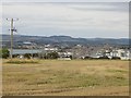
View over Montrose
View northwards from Kirkton of Craig.
Image: © Richard Webb
Taken: 27 Sep 2014
0.04 miles
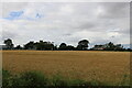
2
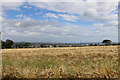
Arable field growing barley near the old Manse of Craig
This field, which often grew crops including potatoes and grass is here seen growing barley.
Image: © Adrian Diack
Taken: 22 Aug 2020
0.04 miles
3
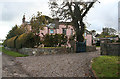
Kirkton House
This elegant house was formerly the manse of Craig parish. It is in so-called Tudor-Gothis style, and dates from 1805, with later wings. The garden is occasionally open under Scotland's Gardens Scheme, but for the rest of the time it can be viewed from the road. It is a Category B Listed Building.
Image: © Anne Burgess
Taken: 5 Oct 2012
0.06 miles
4
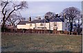
Craig Manse by Montrose
This photo shows a front view of the Manse of Craig towards the end of Rev William Murray Diack's ministry there.
Image: © Adrian Diack
Taken: 28 Mar 1970
0.08 miles
5
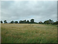
Barley field between Barns of Craig and Kirkton of Craig, Montrose
This westward view shows a field of growing barley between Barns of Craig and Kirkton of Craig by Montrose. The village in the photo is Kirkton of Craig.
Image: © Adrian Diack
Taken: 20 Aug 2020
0.08 miles
6
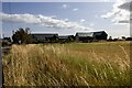
New houses at the Barns of Craig, by Montrose, Angus
The photo shows a small development of houses that are situated on the site of the old farmyard or steading by the crossroads at Barns of Craig. The houses date from the year 2020.
Image: © Adrian Diack
Taken: 22 Aug 2024
0.09 miles
8

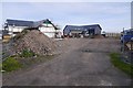
New houses on the former farm steading at Barns of Craig
These new houses are being built on the site of the old farm steading at Barns of Craig.
Image: © Adrian Diack
Taken: 20 Aug 2020
0.10 miles
9
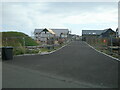
New housing development at Barns of Craig, Montrose
This photo gives an eastward view of new houses being built at Barns of Craig. In former times, when this area was a farmyard, this was the exact site of a Dutch barn and the place where haystacks were built.
Image: © Adrian Diack
Taken: 20 Aug 2020
0.10 miles
10
Kirkton of Craig viewed from a west-northwestery direction
This photo shows Kirkton of Craig, by Montrose, viewed from a west-northwesterly direction.
Image: © Adrian Diack
Taken: 22 Aug 2020
0.11 miles