IMAGES TAKEN NEAR TO
MONTROSE, DD10 9SQ
Introduction
This page details the photographs taken nearby to DD10 9SQ by members of the Geograph project.
The Geograph project started in 2005 with the aim of publishing, organising and preserving representative images for every square kilometre of Great Britain, Ireland and the Isle of Man.

There are currently over 7.5m images from over14,400 individuals and you can help contribute to the project by visiting https://www.geograph.org.uk
Image Map
Images are licensed for reuse under creativecommons.org/licenses/by-sa/2.0
Notes
- Clicking on the map will re-center to the selected point.
- The higher the marker number, the further away the image location is from the centre of the postcode.
Image Listing (8 Images Found)
Images are licensed for reuse under creativecommons.org/licenses/by-sa/2.0
Image
Details
Distance
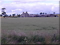
1
Scotstoun of Usan
A traditional stone farmhouse, separated by a minor road from the steading to the left.
Image: © Anne Burgess
Taken: 5 Oct 2012
0.00 miles
2
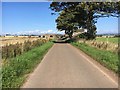
Scotston of Usan
Lane at Scotston of Usan
Image: © Shaun Ferguson
Taken: 31 Aug 2018
0.02 miles
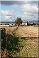
3
Scotston of Usan
Viewed from a nearby rail bridge, overfields.
Image: © Stanley Howe
Taken: 24 Jul 2015
0.03 miles
4

Ploughed Field and Scotston of Usan
Image: © Dominic Dawn Harry and Jacob Paterson
Taken: 14 Feb 2006
0.05 miles
5
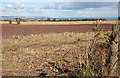
Near Scotstoun
Ploughed fields and straw bales in autumn sunshine. Scotston of Usan is in the middle distance, left of centre, and to its right is Scurdie Ness Lighthouse.
Image: © Anne Burgess
Taken: 5 Oct 2012
0.22 miles
6
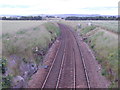
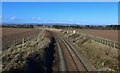
Down line East Coast Main Line
From the road bridge near Seaton of Usan. Montrose the next station.
Image: © Stanley Howe
Taken: 24 Jul 2015
0.23 miles
7
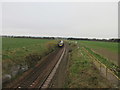
East Coast Railway Line at Usan
Train heading for Montrose on the line near Usan.
Image: © Scott Cormie
Taken: 23 Apr 2020
0.23 miles