IMAGES TAKEN NEAR TO
Riverside Road, MONTROSE, DD10 9NJ
Introduction
This page details the photographs taken nearby to Riverside Road, DD10 9NJ by members of the Geograph project.
The Geograph project started in 2005 with the aim of publishing, organising and preserving representative images for every square kilometre of Great Britain, Ireland and the Isle of Man.

There are currently over 7.5m images from over14,400 individuals and you can help contribute to the project by visiting https://www.geograph.org.uk
Image Map
Images are licensed for reuse under creativecommons.org/licenses/by-sa/2.0
Notes
- Clicking on the map will re-center to the selected point.
- The higher the marker number, the further away the image location is from the centre of the postcode.
Image Listing (162 Images Found)
Images are licensed for reuse under creativecommons.org/licenses/by-sa/2.0
Image
Details
Distance
1
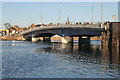
New Road Bridge over River South Esk
Opened December 2005
Image: © Ian Cleland
Taken: 31 Jan 2006
0.02 miles
2
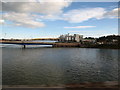
Angus Cereals grain storage facility
Beside the southern end of Montrose road bridge. Taken from a train on Montrose railway viaduct when the tide was in
Image: © Maggie Cox
Taken: 5 Oct 2013
0.03 miles
3
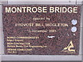
Commemorative stone, Montrose road bridge
Plaque built into the new road bridge at Montrose.
Image: © Dona Robbins
Taken: 31 Oct 2010
0.04 miles
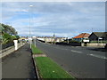
4
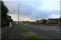
The A92 on Rossie Island, Montrose, Angus
This photo looks in a north-northeast direction and it shows the northern section of the A92 on Rossie Island before the bridge over the River South Esk. This is often a very busy road but it is pictured here at a quiet time in the evening.
Image: © Andrew Diack
Taken: 21 Aug 2020
0.05 miles
5
Rossie Island Road (A92)
Heading north west into Montrose.
Image: © JThomas
Taken: 23 Oct 2013
0.05 miles
6
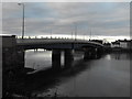
Road bridge, Montrose
The west side of the new road bridge at Montrose. The South Esk river flows underneath from Montrose Basin to the harbour and then the North Sea.
Image: © Dona Robbins
Taken: 31 Oct 2010
0.05 miles
7
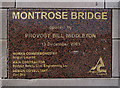
A plaque on Montrose Bridge
For a view of the bridge, see Image]
Image: © Walter Baxter
Taken: 19 Apr 2013
0.05 miles
8
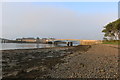
Rossie Island shoreline showing a division of surfaces
This photo shows that the inner shoreline nearer the tidal flow of the River South Esk is composed of mud with seaweed growing on top whereas that part further from the water is a beach of pebbles.
Image: © Andrew Diack
Taken: 29 Jul 2019
0.07 miles
9
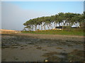
Tree-lined bank on Rossie Island by the New Bridge
The trees, in this photo, occupy an exposed position on the northern side of Rossie Island and their trunks and branches have a somewhat twisted appearance.
Image: © Adrian Diack
Taken: 29 Jul 2019
0.07 miles
10

Esk Road, Rossie Island
The 2005 Montrose Bridhe in the background.
Image: © Richard Webb
Taken: 22 Jul 2024
0.07 miles