IMAGES TAKEN NEAR TO
MONTROSE, DD10 9JS
Introduction
This page details the photographs taken nearby to DD10 9JS by members of the Geograph project.
The Geograph project started in 2005 with the aim of publishing, organising and preserving representative images for every square kilometre of Great Britain, Ireland and the Isle of Man.

There are currently over 7.5m images from over14,400 individuals and you can help contribute to the project by visiting https://www.geograph.org.uk
Image Map
Images are licensed for reuse under creativecommons.org/licenses/by-sa/2.0
Notes
- Clicking on the map will re-center to the selected point.
- The higher the marker number, the further away the image location is from the centre of the postcode.
Image Listing (8 Images Found)
Images are licensed for reuse under creativecommons.org/licenses/by-sa/2.0
Image
Details
Distance
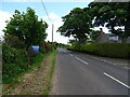
1
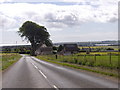
West Mains of Rosemount
By a minor road descending into Hillside village. North Sea ahead and Montrose Basin on the right.
Image: © Stanley Howe
Taken: 24 Jul 2015
0.01 miles
2
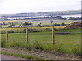
View southards from near West Mains of Rosemount
Towards Montrose Basin, with the rail bridge over its connection to the North Sea seen in the centre distance.
Image: © Stanley Howe
Taken: 24 Jul 2015
0.04 miles
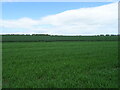
3
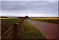
Hillside of Hedderwick
A glimpse of the North Sea and fields full of rape.
Image: © Tom Courtney
Taken: 17 May 1990
0.09 miles
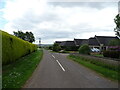
4
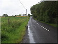
Main Road
Main Road nearing Hillhead of Hedderwick
Image: © Shaun Ferguson
Taken: 18 Aug 2011
0.09 miles