IMAGES TAKEN NEAR TO
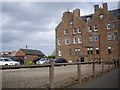
The Maltings, MONTROSE, DD10 8PF
Introduction
This page details the photographs taken nearby to The Maltings, DD10 8PF by members of the Geograph project.
The Geograph project started in 2005 with the aim of publishing, organising and preserving representative images for every square kilometre of Great Britain, Ireland and the Isle of Man.

There are currently over 7.5m images from over14,400 individuals and you can help contribute to the project by visiting https://www.geograph.org.uk
Image Map
Images are licensed for reuse under creativecommons.org/licenses/by-sa/2.0
Notes
- Clicking on the map will re-center to the selected point.
- The higher the marker number, the further away the image location is from the centre of the postcode.
Image Listing (52 Images Found)
Images are licensed for reuse under creativecommons.org/licenses/by-sa/2.0
Image
Details
Distance
1
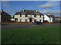
Private car park, Bents Road, Montrose
At the rear of a large residential care home.
Image: © Stanley Howe
Taken: 20 Aug 2013
0.07 miles
2
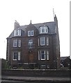
A residential care home on Foulds Road
Montrose.
Image: © Stanley Howe
Taken: 20 Aug 2013
0.08 miles
3
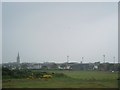
Montrose: the town from the seaside
The football ground is prominent on the right. Apologies for the poor quality which was affected by the weather.
Image: © Bill Boaden
Taken: 10 Aug 2007
0.09 miles
4
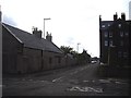
Junction of Faulds Road and Bents Road, Montrose
Image: © Stanley Howe
Taken: 20 Aug 2013
0.10 miles
5
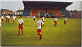
Links Park Grandstand
The young Dons selection limbers up before the Montrose - Aberdeen friendly match.
Image: © Colin Smith
Taken: 26 Jul 2006
0.11 miles

7

Aberdeen Railway: Montrose branch
A branch line once served Montrose when there were two rival railway companies here. The station and branch were closed in favour of the modern station on the North British Railway's through route. Now National Cycle Route 1 uses the trackbed to leave Montrose northwards. The building looks as if it may have been part of the railway.
Image: © Richard Webb
Taken: 21 Sep 2009
0.15 miles
8
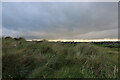
Sand dune vegetation and grassland used for sports, Montrose
This photo shows part of a line of sand dunes, near Traill Pavilion, which run parallel to the coast. A short distance inland, there is another parallel line of pitches and golf links. The two areas of grassland, though close to each other, have sharp boundaries as they represent distinctive forms of land use.
Image: © Andrew Diack
Taken: 21 Aug 2020
0.16 miles
10
![Once were trains [2]](https://s3.geograph.org.uk/geophotos/05/03/09/5030983_fbe2d13f_120x120.jpg)
Once were trains [2]
The grass verge marks the line of the trackbed of the Aberdeen Railway (later the Caledonian Railway) branch line that led from the main Forfar to Aberdeen line at Dubton Junction to Montrose. The branch opened in 1849 and closed in 1934.
Image: © Michael Dibb
Taken: 13 Jun 2016
0.16 miles