IMAGES TAKEN NEAR TO
Beacon Road, MONTROSE, DD10 8EG
Introduction
This page details the photographs taken nearby to Beacon Road, DD10 8EG by members of the Geograph project.
The Geograph project started in 2005 with the aim of publishing, organising and preserving representative images for every square kilometre of Great Britain, Ireland and the Isle of Man.

There are currently over 7.5m images from over14,400 individuals and you can help contribute to the project by visiting https://www.geograph.org.uk
Image Map
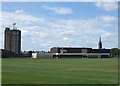
Images are licensed for reuse under creativecommons.org/licenses/by-sa/2.0
Notes
- Clicking on the map will re-center to the selected point.
- The higher the marker number, the further away the image location is from the centre of the postcode.
Image Listing (58 Images Found)
Images are licensed for reuse under creativecommons.org/licenses/by-sa/2.0
Image
Details
Distance
3
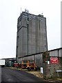
Tall and ugly
This unlovely structure is on the site of an old flour mill. East Coast Viners are an animal foodstuffs manufacturer.
Image: © Michael Dibb
Taken: 13 Jun 2016
0.13 miles
5
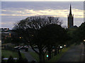
Dusk at Montrose
Looking towards the town centre with a view of its beautiful steeple.
Image: © Ann Harrison
Taken: 11 May 2009
0.16 miles
6
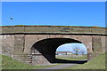
Road bridge & dismantled railway, Montrose
Image: © Leslie Barrie
Taken: 6 Apr 2013
0.17 miles
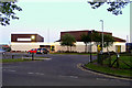
7
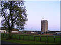
Grain Store at Montrose
This is the school playing fields in front of the grain store.
Image: © Ann Harrison
Taken: 11 May 2009
0.17 miles
8
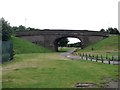
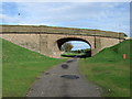
Once were trains
The bridge carries Marine Avenue over the former trackbed of the Aberdeen Railway (later the Caledonian Railway) branch line that led from the main Forfar to Aberdeen line at Dubton Junction and opened in 1849, closing in 1934. The trackbed is now a walkway/cycleway.
Image: © Michael Dibb
Taken: 17 Jun 2016
0.17 miles
9
Bridge over cycle track
On a disused railway.
Image: © JThomas
Taken: 23 Oct 2013
0.17 miles
10
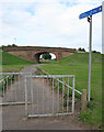
Cycleway
This forms part of national cycle route No 1, and uses the trackbed of the Montrose Branch of the London and North Eastern Railway.
Image: © Anne Burgess
Taken: 27 Aug 2013
0.17 miles