IMAGES TAKEN NEAR TO
Bridge Street, MONTROSE, DD10 8AJ
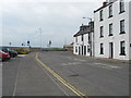
Introduction
This page details the photographs taken nearby to Bridge Street, DD10 8AJ by members of the Geograph project.
The Geograph project started in 2005 with the aim of publishing, organising and preserving representative images for every square kilometre of Great Britain, Ireland and the Isle of Man.

There are currently over 7.5m images from over14,400 individuals and you can help contribute to the project by visiting https://www.geograph.org.uk
Image Map
Images are licensed for reuse under creativecommons.org/licenses/by-sa/2.0
Notes
- Clicking on the map will re-center to the selected point.
- The higher the marker number, the further away the image location is from the centre of the postcode.
Image Listing (194 Images Found)
Images are licensed for reuse under creativecommons.org/licenses/by-sa/2.0
Image
Details
Distance
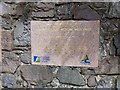
1
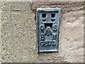
Ordnance Survey Flush Bracket G875
This bracket can be found on the wall of a private dwelling in Bridge Street, Montrose.
The recorded details give a height of 6.6457 metres above sea level.
For more detail see : https://www.bench-marks.org.uk/bm519
Image: © Peter Wood
Taken: 11 Aug 2021
0.03 miles
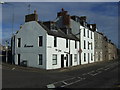
2
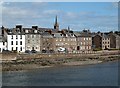
Montrose from Montrose Bridge
These buildings are at Wharf Street with the spire of the Old and St Andrew’s Church prominent in the background.
Image: © Walter Baxter
Taken: 19 Apr 2013
0.03 miles
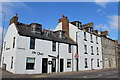
3
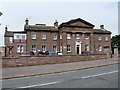
Montrose Infirmary
This early purpose-built hospital dates to 1839. Listed, category A, with details at: http://www.britishlistedbuildings.co.uk/sc-38112-bridge-street-montrose-infirmary-includin#.V4JFLTU5t8E
Image: © Michael Dibb
Taken: 13 Jun 2016
0.03 miles
4

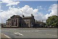
Wharf Street, Montrose at its junction with Bridge Street
Image: © Alan Morrison
Taken: 16 Oct 2008
0.03 miles
5
Montrose Royal Infirmary, Bridge Street, Montrose
Montrose Infirmary was designed by James Collie in the Greek Revival style and it opened in 1839. It was granted a Royal Charter in 1913 and later joined the NHS in 1948. Despite objections from Montrose GP’s, councillors, local historians and members of the public, the A listed building was declared as surplus to requirements by the NHS Tayside Board. In consequence of that decision, the building now stands at a pivotal point in its history as it awaits purchase by a new owner.
Image: © Andrew Diack
Taken: 21 Aug 2020
0.04 miles
6
Scene near Montrose docks.
White washed houses, road junction and car park near the Seamen's Mission.
Image: © James Denham
Taken: 1 Jun 2010
0.04 miles
7
Inner relief road
A plaque inset into the wall commemorating the opening of the inner relief road in 1997. Previously the traffic would have proceeded along Bridge Street and through the town via the main shopping street (High Street), Murray Street and North Esk Road.
Image: © Michael Dibb
Taken: 13 Jun 2016
0.04 miles
9
The Quay, Montrose
Restaurant on Wharf Street
Image: © Leslie Barrie
Taken: 6 Apr 2013
0.05 miles
10
The Quay Restaurant, Montrose
On Wharf Street.
Image: © JThomas
Taken: 23 Oct 2013
0.05 miles