IMAGES TAKEN NEAR TO
Queen Johanna Place, MONTROSE, DD10 0PY
Introduction
This page details the photographs taken nearby to Queen Johanna Place, DD10 0PY by members of the Geograph project.
The Geograph project started in 2005 with the aim of publishing, organising and preserving representative images for every square kilometre of Great Britain, Ireland and the Isle of Man.

There are currently over 7.5m images from over14,400 individuals and you can help contribute to the project by visiting https://www.geograph.org.uk
Image Map
Images are licensed for reuse under creativecommons.org/licenses/by-sa/2.0
Notes
- Clicking on the map will re-center to the selected point.
- The higher the marker number, the further away the image location is from the centre of the postcode.
Image Listing (14 Images Found)
Images are licensed for reuse under creativecommons.org/licenses/by-sa/2.0
Image
Details
Distance
1
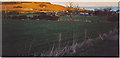
Townhead, Inverbervie
Looking down on to Inverbervie from the hill road to the west. Bervie Head, Bervie Water Brig and Bervie Kirk are catching the last sunrays of the evening. The fields in the foreground have scrubby hedges of gorse, long grass and scattered trees.
Image: © Colin Smith
Taken: 15 Apr 2006
0.01 miles
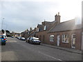
2
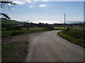
Road down to Inverbervie
Road down to Inverbervie with the church tower and bay in the distance
Image: © Shaun Ferguson
Taken: 31 May 2010
0.10 miles
3
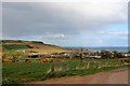
Fields above Bervie
Farmland above Inverbervie.
Image: © Andrew Wood
Taken: 21 Apr 2017
0.18 miles
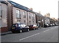
4
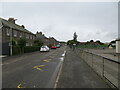
Church Street, Inverbervie
Looking north-westward from beside Bervie School.
Image: © Peter Wood
Taken: 7 Aug 2021
0.20 miles
5
The scene at Inverbervie in Aberdeenshire
Image: © James Denham
Taken: 30 Jul 2012
0.20 miles
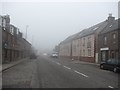
6
Looking back on the main street at Inverbervie
In Aberdeenshire.
Image: © James Denham
Taken: 30 Jul 2012
0.20 miles
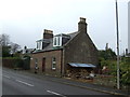
7
King Street / Montrose Road, Inverbervie
Image: © Richard Webb
Taken: 3 Aug 2011
0.21 miles
8
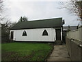
St David of Scotland Episcopal Church
The white-washed tin church of St David in Inverbervie.
Image: © Scott Cormie
Taken: 25 Nov 2022
0.21 miles
10

Ordnance Survey Flush Bracket S7021
This bracket can be found on the wall of Bervie School, Inverbervie.
The recorded details give a height of 28.805 metres above sea level.
For more detail see : https://www.bench-marks.org.uk/bm488
Image: © Peter Wood
Taken: 7 Aug 2021
0.22 miles