IMAGES TAKEN NEAR TO
Inverbervie, MONTROSE, DD10 0PL
Introduction
This page details the photographs taken nearby to DD10 0PL by members of the Geograph project.
The Geograph project started in 2005 with the aim of publishing, organising and preserving representative images for every square kilometre of Great Britain, Ireland and the Isle of Man.

There are currently over 7.5m images from over14,400 individuals and you can help contribute to the project by visiting https://www.geograph.org.uk
Image Map
Images are licensed for reuse under creativecommons.org/licenses/by-sa/2.0
Notes
- Clicking on the map will re-center to the selected point.
- The higher the marker number, the further away the image location is from the centre of the postcode.
Image Listing (7 Images Found)
Images are licensed for reuse under creativecommons.org/licenses/by-sa/2.0
Image
Details
Distance
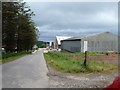
1
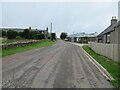
Minor road at Dendoldrum Farm
Looking south-westward.
Image: © Peter Wood
Taken: 7 Aug 2021
0.01 miles
2
Road to Inverbervie
Road to Inverbervie passing through Dendoldrum
Image: © Shaun Ferguson
Taken: 31 May 2010
0.02 miles
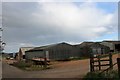
3
Dendoldrum Farm, Inververbie
Dendoldrum Farm near Inververbie
Image: © Stuart Reid
Taken: 27 May 2006
0.03 miles
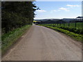
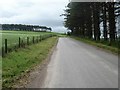
4
C14K (Aberdeenshire) Road at Dendoldrum
The C14K road heading westwards up the hill to Dendoldrum.
Image: © Scott Cormie
Taken: 12 Sep 2020
0.04 miles
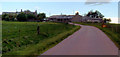
5
Dendoldrum farm
This neat and tidy farm has the wonderful name of Dendoldrum. The road leads to Inverbervie.
Image: © Michael Dibb
Taken: 16 Jun 2016
0.07 miles
6
Dendoldrum Farm
A farm on the outskirts of Inverbervie.
Image: © Andrew Wood
Taken: 21 Apr 2017
0.09 miles
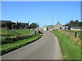
7
The road to Townhead
Seen from the same viewpoint as Image, the country road leads to Townhead on the B967.
Image: © Michael Dibb
Taken: 16 Jun 2016
0.19 miles