IMAGES TAKEN NEAR TO
Inverbervie, MONTROSE, DD10 0PG
Introduction
This page details the photographs taken nearby to DD10 0PG by members of the Geograph project.
The Geograph project started in 2005 with the aim of publishing, organising and preserving representative images for every square kilometre of Great Britain, Ireland and the Isle of Man.

There are currently over 7.5m images from over14,400 individuals and you can help contribute to the project by visiting https://www.geograph.org.uk
Image Map
Images are licensed for reuse under creativecommons.org/licenses/by-sa/2.0
Notes
- Clicking on the map will re-center to the selected point.
- The higher the marker number, the further away the image location is from the centre of the postcode.
Image Listing (8 Images Found)
Images are licensed for reuse under creativecommons.org/licenses/by-sa/2.0
Image
Details
Distance
1
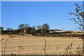
Hallgreen Mains
The mains with its C listed frontage. Dating from the 1830's it is symmetrical with an arched pend and gabled winds in white harl.
Image: © Andrew Wood
Taken: 19 Nov 2016
0.02 miles
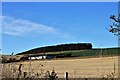
2
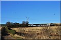
Mains of Hallgreen
Hallgreen farm from the path through a gap in a hedgerow.
Image: © Andrew Wood
Taken: 19 Nov 2016
0.03 miles
3
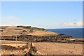
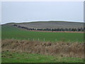
Track Downhill to Bervie
Nothing nicer than to look back downhill on an ascent, Sillyflatt Farm to the right and Bervie Brow in the distance.
Image: © Andrew Wood
Taken: 19 Nov 2016
0.15 miles
4
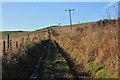
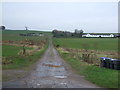
Path to Benholm
A farm track leading up the Caldwell Braes and on to Benholm, a pleasant walkway.
Image: © Andrew Wood
Taken: 19 Nov 2016
0.15 miles
5
Cottage by Hallgreen Mains
A whitewashed cottage to the south of Hallgreen Mains and a plantation on Knox Hill behind.
Image: © Andrew Wood
Taken: 19 Nov 2016
0.16 miles