IMAGES TAKEN NEAR TO
Johnshaven, MONTROSE, DD10 0HZ
Introduction
This page details the photographs taken nearby to DD10 0HZ by members of the Geograph project.
The Geograph project started in 2005 with the aim of publishing, organising and preserving representative images for every square kilometre of Great Britain, Ireland and the Isle of Man.

There are currently over 7.5m images from over14,400 individuals and you can help contribute to the project by visiting https://www.geograph.org.uk
Image Map
Images are licensed for reuse under creativecommons.org/licenses/by-sa/2.0
Notes
- Clicking on the map will re-center to the selected point.
- The higher the marker number, the further away the image location is from the centre of the postcode.
Image Listing (3 Images Found)
Images are licensed for reuse under creativecommons.org/licenses/by-sa/2.0
Image
Details
Distance
1
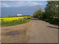
Road to Mains of Brotherton
Road to Mains of Brotherton passing Craighead
Image: © Shaun Ferguson
Taken: 1 Jun 2010
0.07 miles
2
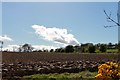
Ploughing by Muirton
A ploughed field near Muirton Farm just visible on the right.
Image: © Andrew Wood
Taken: 21 Apr 2017
0.16 miles
3
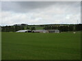
Farm sheds at Craighead
Looking north from the roadside to three large sheds at Craighead.
Image: © Scott Cormie
Taken: 4 Apr 2022
0.25 miles