IMAGES TAKEN NEAR TO
Johnshaven, MONTROSE, DD10 0HR
Introduction
This page details the photographs taken nearby to DD10 0HR by members of the Geograph project.
The Geograph project started in 2005 with the aim of publishing, organising and preserving representative images for every square kilometre of Great Britain, Ireland and the Isle of Man.

There are currently over 7.5m images from over14,400 individuals and you can help contribute to the project by visiting https://www.geograph.org.uk
Image Map
Images are licensed for reuse under creativecommons.org/licenses/by-sa/2.0
Notes
- Clicking on the map will re-center to the selected point.
- The higher the marker number, the further away the image location is from the centre of the postcode.
Image Listing (5 Images Found)
Images are licensed for reuse under creativecommons.org/licenses/by-sa/2.0
Image
Details
Distance
1
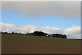
Stone of Benholm
The farm of Stone of Benholm across one of its cultivated fields.
Image: © Andrew Wood
Taken: 21 Apr 2017
0.01 miles
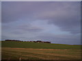
2
Stone of Benholm
Looking northwards to the Stone of Benholm from the C7K road.
Image: © Scott Cormie
Taken: 4 Apr 2022
0.01 miles
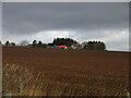
3
Stone of Benholm Farm
Image: © Dominic Dawn Harry and Jacob Paterson
Taken: 21 Jan 2006
0.05 miles
4
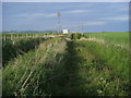
Footpath to Kirktown of Benholm
Footpath to Kirktown of Benholm passing the mast near Stone of Benholm
Image: © Shaun Ferguson
Taken: 1 Jun 2010
0.23 miles
5
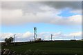
Comms Mast
A telecommunication mast near to Stone of Benholm farm.
Image: © Andrew Wood
Taken: 21 Apr 2017
0.24 miles