IMAGES TAKEN NEAR TO
St. Cyrus, MONTROSE, DD10 0DS
Introduction
This page details the photographs taken nearby to DD10 0DS by members of the Geograph project.
The Geograph project started in 2005 with the aim of publishing, organising and preserving representative images for every square kilometre of Great Britain, Ireland and the Isle of Man.

There are currently over 7.5m images from over14,400 individuals and you can help contribute to the project by visiting https://www.geograph.org.uk
Image Map
Images are licensed for reuse under creativecommons.org/licenses/by-sa/2.0
Notes
- Clicking on the map will re-center to the selected point.
- The higher the marker number, the further away the image location is from the centre of the postcode.
Image Listing (5 Images Found)
Images are licensed for reuse under creativecommons.org/licenses/by-sa/2.0
Image
Details
Distance
1
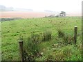
Wideopen Croft
View on a dreich afternoon from the Wide Open road.
Image: © Richard Webb
Taken: 2 Aug 2011
0.06 miles
2
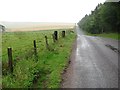
Wide Open Road
A pass over the southern end of Hill of Garvock. Dreich day, It was to remain like this all the way to Ellon.
Image: © Richard Webb
Taken: 2 Aug 2011
0.08 miles
3
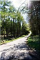
Road Through the Trees
A slip road to Marykirk through Kirktonhill woods.
Image: © Andrew Wood
Taken: 7 May 2010
0.16 miles
4
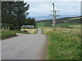
High point of the road at Hospital Shields
Looking north-westwards from the summit of the road at Hospital Shields.
Image: © Scott Cormie
Taken: 29 Sep 2019
0.20 miles
5
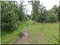
Track through Kirtonhill Woods
Looking north-westward.
Image: © Peter Wood
Taken: 8 Aug 2021
0.21 miles