IMAGES TAKEN NEAR TO
St. Cyrus, MONTROSE, DD10 0DR
Introduction
This page details the photographs taken nearby to DD10 0DR by members of the Geograph project.
The Geograph project started in 2005 with the aim of publishing, organising and preserving representative images for every square kilometre of Great Britain, Ireland and the Isle of Man.

There are currently over 7.5m images from over14,400 individuals and you can help contribute to the project by visiting https://www.geograph.org.uk
Image Map
Images are licensed for reuse under creativecommons.org/licenses/by-sa/2.0
Notes
- Clicking on the map will re-center to the selected point.
- The higher the marker number, the further away the image location is from the centre of the postcode.
Image Listing (7 Images Found)
Images are licensed for reuse under creativecommons.org/licenses/by-sa/2.0
Image
Details
Distance
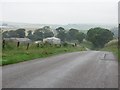
1
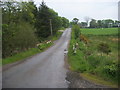
Nearing Sillycoats
Road nearing Sillycoats
Image: © Shaun Ferguson
Taken: 1 Jun 2010
0.10 miles
2
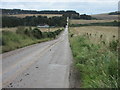
Long Straight
A long stretch of road by Swirlie Den. The Den can be seen in the distance as a patch of green converging on the road.
Image: © Andrew Wood
Taken: 2 Aug 2018
0.15 miles
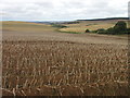
4
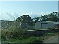
Mud-strewn road
Muddy road heading southwards down the hill near the Mill of Criggie.
Image: © Scott Cormie
Taken: 29 Sep 2019
0.18 miles
5
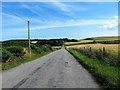
Sillycoats
Road from St Cyrus to Laurencekirk passes Sillycoats.
Image: © Richard Webb
Taken: 2 Aug 2011
0.18 miles
6
Potato field near Sillycoats
Potato field south of Sillycoats, with the Den of Morphie in the distance.
Image: © Scott Cormie
Taken: 29 Sep 2019
0.24 miles
7
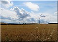
Field by Swirlie Den
A field of Barley by the roadside.
Image: © Andrew Wood
Taken: 2 Aug 2018
0.25 miles