IMAGES TAKEN NEAR TO
St. Cyrus, MONTROSE, DD10 0DN
Introduction
This page details the photographs taken nearby to DD10 0DN by members of the Geograph project.
The Geograph project started in 2005 with the aim of publishing, organising and preserving representative images for every square kilometre of Great Britain, Ireland and the Isle of Man.

There are currently over 7.5m images from over14,400 individuals and you can help contribute to the project by visiting https://www.geograph.org.uk
Image Map
Images are licensed for reuse under creativecommons.org/licenses/by-sa/2.0
Notes
- Clicking on the map will re-center to the selected point.
- The higher the marker number, the further away the image location is from the centre of the postcode.
Image Listing (5 Images Found)
Images are licensed for reuse under creativecommons.org/licenses/by-sa/2.0
Image
Details
Distance
1
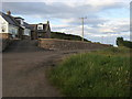
Leading to Gateside
Mains of Bridgeton track leading to Gateside
Image: © Shaun Ferguson
Taken: 15 Aug 2011
0.08 miles
2
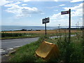
A92 road junction
With a road from Mains of Bridgeton. Foot path continues leading to an old 'Coach Bridge' over Den Finella.
Image: © Stanley Howe
Taken: 31 Jul 2007
0.20 miles
4
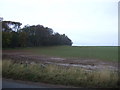
Wheat, Bridgeton
A field of wheat beside a stripwood which shelters Bridgeton Castle.
Image: © Richard Webb
Taken: 2 Aug 2011
0.24 miles
5
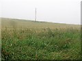
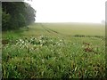
A cold and wet afternoon at Gateside
Low cloud, drizzle and a field of wheat.
Image: © Richard Webb
Taken: 2 Aug 2011
0.25 miles