IMAGES TAKEN NEAR TO
Kirkton Cottages, MONTROSE, DD10 0BX
Introduction
This page details the photographs taken nearby to Kirkton Cottages, DD10 0BX by members of the Geograph project.
The Geograph project started in 2005 with the aim of publishing, organising and preserving representative images for every square kilometre of Great Britain, Ireland and the Isle of Man.

There are currently over 7.5m images from over14,400 individuals and you can help contribute to the project by visiting https://www.geograph.org.uk
Image Map
Images are licensed for reuse under creativecommons.org/licenses/by-sa/2.0
Notes
- Clicking on the map will re-center to the selected point.
- The higher the marker number, the further away the image location is from the centre of the postcode.
Image Listing (69 Images Found)
Images are licensed for reuse under creativecommons.org/licenses/by-sa/2.0
Image
Details
Distance
1
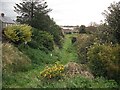
Montrose and Bervie Railway
A branch line, running up the coast, often beneath the cliffs. There were plans to complete the route to Aberdeen to provide a rival service, but there was no construction of what would have been a wasteful duplication. The service to Inverbervie could never have been a serious revenue earner. Here the trackbed passes through St Cyrus.
Image: © Richard Webb
Taken: 21 Sep 2009
0.04 miles
3
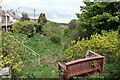
Montrose and Bervie Railway
A branch line, running up the coast, often beneath the cliffs. There were plans to complete the route to Aberdeen to provide a rival service, but there was no construction of what would have been a wasteful duplication. The service to Inverbervie could never have been a serious revenue earner. Here the trackbed leaves St Cyrus in the direction of Montrose.
Image: © Richard Webb
Taken: 21 Sep 2009
0.07 miles
4
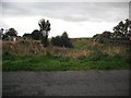
Site of former railway station in St Cyrus
On a branchline from Montrose to Inverbervie.
Image: © Stanley Howe
Taken: 31 Jul 2007
0.11 miles
5
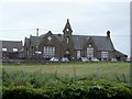
St Cyrus school
Built in 1867, this attractive building is listed, category B, with details at: http://www.britishlistedbuildings.co.uk/sc-16318-st-cyrus-school-st-cyrus#.V5GyqTU5t8E
Image: © Michael Dibb
Taken: 17 Jun 2016
0.11 miles
6
Beach Road, St Cyrus
Looking north-westward.
Image: © Peter Wood
Taken: 8 Aug 2021
0.14 miles
7
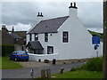
Churchgate cottage
This attractive cottage is adjacent to the church. Listed, category C(S), with details at: http://www.britishlistedbuildings.co.uk/sc-16320-churchgate-cottage-t-b-craig-near-garvock#.V5GxSzU5t8E
Image: © Michael Dibb
Taken: 17 Jun 2016
0.14 miles
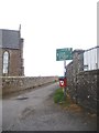
8
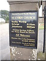
St Cyrus Church notice
At kirkyard gate.
Image: © Stanley Howe
Taken: 20 Aug 2013
0.14 miles
9
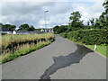
Lane from clifftop path to St Cyrus Church
Image: © Stanley Howe
Taken: 20 Aug 2013
0.14 miles
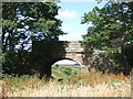
10
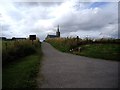
Track to the cliff path, St Cyrus
Between the Parish Church (L) and the school (R).
Image: © Stanley Howe
Taken: 20 Aug 2013
0.15 miles