IMAGES TAKEN NEAR TO
Beachview Grove, MONTROSE, DD10 0AN
Introduction
This page details the photographs taken nearby to Beachview Grove, DD10 0AN by members of the Geograph project.
The Geograph project started in 2005 with the aim of publishing, organising and preserving representative images for every square kilometre of Great Britain, Ireland and the Isle of Man.

There are currently over 7.5m images from over14,400 individuals and you can help contribute to the project by visiting https://www.geograph.org.uk
Image Map
Images are licensed for reuse under creativecommons.org/licenses/by-sa/2.0
Notes
- Clicking on the map will re-center to the selected point.
- The higher the marker number, the further away the image location is from the centre of the postcode.
Image Listing (18 Images Found)
Images are licensed for reuse under creativecommons.org/licenses/by-sa/2.0
Image
Details
Distance
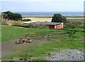
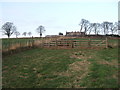
1
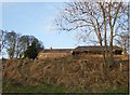
Warburton steading
Disused, and planned for redevelopment.
Image: © Stanley Howe
Taken: 16 Dec 2007
0.01 miles
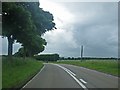
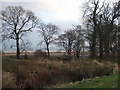
2
View SE from Warburton
Towards the North Sea.
Image: © Stanley Howe
Taken: 7 Aug 2009
0.06 miles
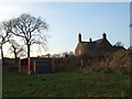
4
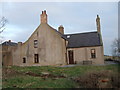
Warburton
Built ca.1820; with later extensions.
Image: © Stanley Howe
Taken: 16 Dec 2007
0.06 miles
5
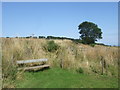
Route of old railway
Between Warburton and Kirkside.
Image: © Stanley Howe
Taken: 7 Aug 2009
0.08 miles
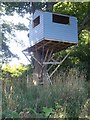
7
Tree-house by A92
Seen from by Warburton.
Image: © Stanley Howe
Taken: 16 Dec 2007
0.08 miles