IMAGES TAKEN NEAR TO
Vicarage Close, ERITH, DA8 1ET
Introduction
This page details the photographs taken nearby to Vicarage Close, DA8 1ET by members of the Geograph project.
The Geograph project started in 2005 with the aim of publishing, organising and preserving representative images for every square kilometre of Great Britain, Ireland and the Isle of Man.

There are currently over 7.5m images from over14,400 individuals and you can help contribute to the project by visiting https://www.geograph.org.uk
Image Map (Loading...)


Getting Data...Please wait
Leaflet Map data © OpenStreetMap
Images are licensed for reuse under creativecommons.org/licenses/by-sa/2.0
Notes
- Clicking on the map will re-center to the selected point.
- The higher the marker number, the further away the image location is from the centre of the postcode.
Image Listing (12 Images Found)
Images are licensed for reuse under creativecommons.org/licenses/by-sa/2.0
Image
Details
Distance
1
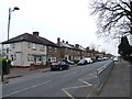
Our Lady of the Angels Roman Catholic Church, Bexley Road, Northumberland Heath, Kent
A large and handsome Catholic church serving a large and multi-ethnic population in the surrounding area.
Image: © Dr Neil Clifton
Taken: 30 Aug 2006
0.03 miles
2
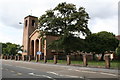
Our Lady of the Angels Roman Catholic Church, Bexley Road
When seen from the north, this fine tree hides the church tower. A Friary is attached to the church - see http://olaerith.org.uk/ and a small cemetery lies beyond the church - see http://www.geograph.org.uk/photo/2009317
Image: © Marathon
Taken: 1 Jul 2010
0.10 miles
3
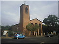
Our Lady of the Angels Roman Catholic Church, Northumberland Heath
This view looks across Bexley Road. A Friary is attached to the church - see http://olaerith.org.uk/
Image: © Marathon
Taken: 1 Jul 2010
0.10 miles
5
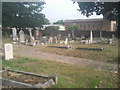
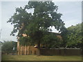
Catholic cemetery at Northumberland Heath
This small cemetery off Bexley Road belongs to Our Lady of the Angels Roman Catholic Church, seen beyond the wall in the distance. For more information about the cemetery see http://www.londongardensonline.org.uk/gardens-online-record.asp?ID=BEX008 and for more information about the Friary nearby see http://olaerith.org.uk/
Image: © Marathon
Taken: 1 Jul 2010
0.16 miles
7
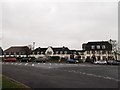
Erith and District Hospital
The old (1924) part of the hospital on Hind Crescent.
Image: © David Anstiss
Taken: 27 Feb 2012
0.19 miles
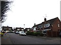
8
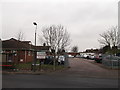
Northumberland Heath Medical Unit
On Hind Crescent.
In the background is more of Erith and District Hospital.
Image: © David Anstiss
Taken: 27 Feb 2012
0.19 miles
9
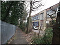
Birch Walk, Erith
This straight path leads from Bexley Road to Frasier Road.
On the right is Birch house.
On the left are trees surrounding an abandoned pit.
Image: © David Anstiss
Taken: 27 Feb 2012
0.19 miles