IMAGES TAKEN NEAR TO
Jenton Avenue, BEXLEYHEATH, DA7 4SP
Introduction
This page details the photographs taken nearby to Jenton Avenue, DA7 4SP by members of the Geograph project.
The Geograph project started in 2005 with the aim of publishing, organising and preserving representative images for every square kilometre of Great Britain, Ireland and the Isle of Man.

There are currently over 7.5m images from over14,400 individuals and you can help contribute to the project by visiting https://www.geograph.org.uk
Image Map
Images are licensed for reuse under creativecommons.org/licenses/by-sa/2.0
Notes
- Clicking on the map will re-center to the selected point.
- The higher the marker number, the further away the image location is from the centre of the postcode.
Image Listing (59 Images Found)
Images are licensed for reuse under creativecommons.org/licenses/by-sa/2.0
Image
Details
Distance
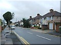
3
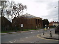
St Peter's Church, Pickford Lane, Bexleyheath
Sunday morning - but the place was completely deserted!
Image: © Dr Neil Clifton
Taken: 9 Apr 2006
0.09 miles
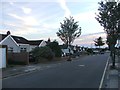
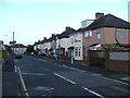
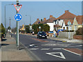
5
Pickford Lane - Bowford Avenue bus stop, Bexleyheath
The northbound stop, Bowford Avenue is the left turn a little way ahead.
Image: © Robin Webster
Taken: 15 Mar 2012
0.10 miles
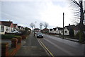
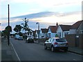
6
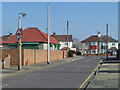
Jenton Avenue at junction with Pickford Lane, Bexleyheath
Looking east.
Image: © Robin Webster
Taken: 15 Mar 2012
0.10 miles
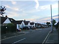
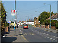
7
Brampton Road, Bexleyheath
Looking north.
Image: © Robin Webster
Taken: 15 Mar 2012
0.10 miles