IMAGES TAKEN NEAR TO
Crook Log, BEXLEYHEATH, DA6 8EQ
Introduction
This page details the photographs taken nearby to Crook Log, DA6 8EQ by members of the Geograph project.
The Geograph project started in 2005 with the aim of publishing, organising and preserving representative images for every square kilometre of Great Britain, Ireland and the Isle of Man.

There are currently over 7.5m images from over14,400 individuals and you can help contribute to the project by visiting https://www.geograph.org.uk
Image Map
Images are licensed for reuse under creativecommons.org/licenses/by-sa/2.0
Notes
- Clicking on the map will re-center to the selected point.
- The higher the marker number, the further away the image location is from the centre of the postcode.
Image Listing (62 Images Found)
Images are licensed for reuse under creativecommons.org/licenses/by-sa/2.0
Image
Details
Distance
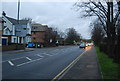
1
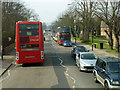
96 buses pass on Crook Log
This road is the old Roman Watling Street, and is straight to the horizon here. The 96 route goes to and from the Bluewater shopping centre, with a long non-stop stage at the eastern end. Viewed from an 89 bus.
Image: © Robin Webster
Taken: 14 Mar 2012
0.02 miles
3
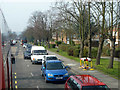
Traffic queue on A207 Crook Log
Caused by road works some way behind the camera.
Image: © Robin Webster
Taken: 14 Mar 2012
0.02 miles
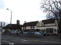
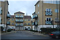
8
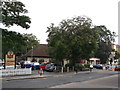
Bexleyheath Toby Carvery
On the A207 Crook Log (road).
Image: © David Anstiss
Taken: 15 Aug 2011
0.05 miles
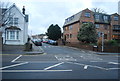
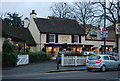
9
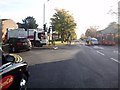
Junction of Brampton Road with Crook Log Broadway
Image: © Bikeboy
Taken: 30 Oct 2012
0.05 miles