IMAGES TAKEN NEAR TO
Elmwood Drive, BEXLEY, DA5 3PS
Introduction
This page details the photographs taken nearby to Elmwood Drive, DA5 3PS by members of the Geograph project.
The Geograph project started in 2005 with the aim of publishing, organising and preserving representative images for every square kilometre of Great Britain, Ireland and the Isle of Man.

There are currently over 7.5m images from over14,400 individuals and you can help contribute to the project by visiting https://www.geograph.org.uk
Image Map
Images are licensed for reuse under creativecommons.org/licenses/by-sa/2.0
Notes
- Clicking on the map will re-center to the selected point.
- The higher the marker number, the further away the image location is from the centre of the postcode.
Image Listing (31 Images Found)
Images are licensed for reuse under creativecommons.org/licenses/by-sa/2.0
Image
Details
Distance
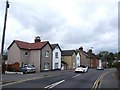
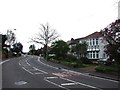
1

Road junction on Elmwood Drive
Elmwood Drive leads from Bridgen Road towards Hurst Road.
On the right, The Drive leads towards Blackfen Road.
Image: © David Anstiss
Taken: 15 Aug 2011
0.05 miles
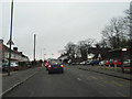
2
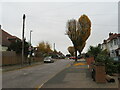
The Drive, Blendon
The Drive is a residential road in the outer suburbs of South East London.
This image was taken on a dull and gloomy November day. Trees were in the process of shedding their leaves, and would soon be bare for the coming winter months.
Image: © Malc McDonald
Taken: 20 Nov 2021
0.05 miles
4

The Anchor Public House, Sidcup
On the junction of the B2210 Blendon Road (in front) and Arbuthnot Lane (behind the pub).
Image: © David Anstiss
Taken: 15 Aug 2011
0.09 miles
5
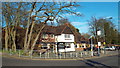
The Anchor, Bexley
The Anchor pub near Bexley.
Image: © Malc McDonald
Taken: 15 Mar 2014
0.09 miles

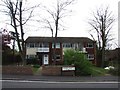
9
Bridgen Road, Bexley
The Anchor pub can be seen on the right. In typically British style the road has three names in just over a mile, the B2210 goes from Parkhill Road to Bridgen Road, which only extends a few hundred yards before changing to Blendon Road. It would take little effort for councils to undo such historic artefacts but they appear to encourage them.
Image: © David Howard
Taken: 6 Jan 2013
0.11 miles
10
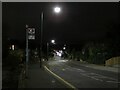
Blendon Road, Blendon, after dark
A Transport for London bus stop on Blendon Road, in the outer suburbs of South East London. The road forms part of the route of the B2210.
This image was taken at around 5pm on a November evening. Darkness had already fallen.
Image: © Malc McDonald
Taken: 20 Nov 2021
0.12 miles