IMAGES TAKEN NEAR TO
Wakeford Close, BEXLEY, DA5 3AD
Introduction
This page details the photographs taken nearby to Wakeford Close, DA5 3AD by members of the Geograph project.
The Geograph project started in 2005 with the aim of publishing, organising and preserving representative images for every square kilometre of Great Britain, Ireland and the Isle of Man.

There are currently over 7.5m images from over14,400 individuals and you can help contribute to the project by visiting https://www.geograph.org.uk
Image Map
Images are licensed for reuse under creativecommons.org/licenses/by-sa/2.0
Notes
- Clicking on the map will re-center to the selected point.
- The higher the marker number, the further away the image location is from the centre of the postcode.
Image Listing (41 Images Found)
Images are licensed for reuse under creativecommons.org/licenses/by-sa/2.0
Image
Details
Distance
1
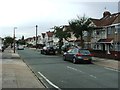
Low-rise under the cables
A row of three single storey premises beneath the cableway.
Image: © Des Blenkinsopp
Taken: 4 Jun 2015
0.05 miles
5

Hurst Community Centre
On Hurst Road.
See Image for more details about the place.
Image: © David Anstiss
Taken: 15 Aug 2011
0.13 miles
6
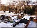
Bexley Park Wood in Snow
Photo of Bexley Park Wood. Taken 3rd February 2009.
River Shuttle can be seen snaking through the snow!
Image: © john driscoll
Taken: 3 Feb 2009
0.13 miles
7
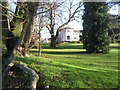
Hurst Community Centre
First mention of the house can be traced back to 1681 but the name Hurst Place does not occur until 1860. Hurst Place was used as a convalescent home in the First World War, and in the Second World War its cellars were used as A.R.P headquarters and bomb shelters. The Council purchased the property in 1946 and used it to house bombed-out families and it is now a community centre with attractive grounds, as seen here.
Image: © Marathon
Taken: 8 Feb 2011
0.14 miles
8
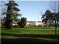
Hurst Community Centre
First mention of the house can be traced back to 1681 but the name Hurst Place does not occur until 1860. Hurst Place was used as a convalescent home in the First World War, and in the Second World War its cellars were used as A.R.P headquarters and bomb shelters. The Council purchased the property in 1946 and used it to house bombed-out families. It is now a community centre with attractive grounds, as seen here.
Image: © Marathon
Taken: 8 Feb 2011
0.14 miles
9
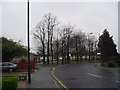
Roadside trees, Bexley, Kent
It's a wet Saturday afternoon in April, but this small patch of trees at the junction of Hurst Road with Stansted Crescent still lift the spirit, leafless though they may be.
Image: © Dr Neil Clifton
Taken: 15 Apr 2006
0.15 miles