IMAGES TAKEN NEAR TO
Stable Lane, BEXLEY, DA5 2AW
Introduction
This page details the photographs taken nearby to Stable Lane, DA5 2AW by members of the Geograph project.
The Geograph project started in 2005 with the aim of publishing, organising and preserving representative images for every square kilometre of Great Britain, Ireland and the Isle of Man.

There are currently over 7.5m images from over14,400 individuals and you can help contribute to the project by visiting https://www.geograph.org.uk
Image Map
Images are licensed for reuse under creativecommons.org/licenses/by-sa/2.0
Notes
- Clicking on the map will re-center to the selected point.
- The higher the marker number, the further away the image location is from the centre of the postcode.
Image Listing (8 Images Found)
Images are licensed for reuse under creativecommons.org/licenses/by-sa/2.0
Image
Details
Distance
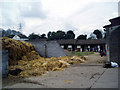

3
Slade stables, Stable Lane, Bexley, Kent
This is an area where there is plenty of interest in riding, and Slade is one of the larger stables. It struck me as a very well run establishment. The horses were quiet and well-behaved, all the learner-riders looked happy, and there were plenty of staff in attendance.
Image: © Dr Neil Clifton
Taken: 16 Apr 2006
0.10 miles
4
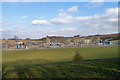
Hurst Grid Sub Station
A enormous installation, not fitting in a widest angle view across a large field.
Image: © Robin Webster
Taken: 10 Mar 2012
0.18 miles
5
The Old Wick Public House, Bexley
On the A2018 Vicarage Road.
Note; no pub sign.
Image: © David Anstiss
Taken: 6 Aug 2010
0.22 miles
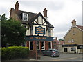
6

The Coach and Horses public house, Bexley
On the A223 North Cray Road.
Image: © David Anstiss
Taken: 6 Aug 2010
0.23 miles
7
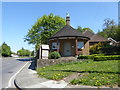
The lodge to the former Mount Mascal
Mount Mascal was built around the end of the 16th century and stood on the hillside overlooking the North Cray Road, close to where Home Close Farm and Mount Mascal Farm are now. The location of Mount Mascal and its lodge can be seen on this map, dating from just before the First World War: https://maps.nls.uk/geo/explore/?fbclid=IwAR0NRRyYPoOtuooyDvNaHoYbLlHTnAyHqTQysjxp4C-x4flqcKKqEmYHyS0#zoom=16&lat=51.43384&lon=0.14687&layers=6&b=1
Mount Mascal was demolished in 1957, and between 1967 and 1969, most of the winding village lane and the properties on its east side were obliterated by the A223 dual carriageway. However, the lodge to Mount Mascal survived as can be seen here.
Image: © Marathon
Taken: 21 Apr 2020
0.24 miles
8
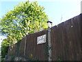
Dummy with a Covid 19 mask
This man looks out over the fence of the lodge seen at https://www.geograph.org.uk/photo/6450244 on to North Cray Road. He has been a fixture there for many years. At one stage he was stolen but was then recovered. He was photographed here at the height of the lockdown in 2020.
Image: © Marathon
Taken: 21 Apr 2020
0.24 miles