IMAGES TAKEN NEAR TO
Mornington Court, BEXLEY, DA5 2AU
Introduction
This page details the photographs taken nearby to Mornington Court, DA5 2AU by members of the Geograph project.
The Geograph project started in 2005 with the aim of publishing, organising and preserving representative images for every square kilometre of Great Britain, Ireland and the Isle of Man.

There are currently over 7.5m images from over14,400 individuals and you can help contribute to the project by visiting https://www.geograph.org.uk
Image Map
Images are licensed for reuse under creativecommons.org/licenses/by-sa/2.0
Notes
- Clicking on the map will re-center to the selected point.
- The higher the marker number, the further away the image location is from the centre of the postcode.
Image Listing (27 Images Found)
Images are licensed for reuse under creativecommons.org/licenses/by-sa/2.0
Image
Details
Distance
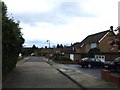
1

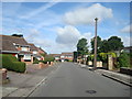
The Firs, near Bexley
The Firs is a short residential cul-de-sac near Bexley, on the outermost fringe of South East London.
Image: © Malc McDonald
Taken: 14 Jul 2019
0.04 miles
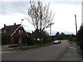
2

Fraser Close, near Bexley
Fraser Close is a short residential cul-de-sac on the outermost fringes of south east London.
Image: © Malc McDonald
Taken: 14 Jul 2019
0.06 miles
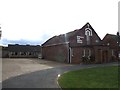
3
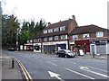
Baldwyn's Park Baptist Church
On A2018 Dartford Road.
Image: © David Anstiss
Taken: 29 Apr 2009
0.06 miles
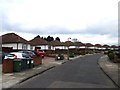
4

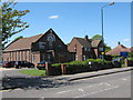
Dartford Road, near Bexley
Dartford Road, near Bexley on the outermost fringe of south east London.
Image: © Malc McDonald
Taken: 14 Jul 2019
0.06 miles