IMAGES TAKEN NEAR TO
Newick Close, BEXLEY, DA5 1PZ
Introduction
This page details the photographs taken nearby to Newick Close, DA5 1PZ by members of the Geograph project.
The Geograph project started in 2005 with the aim of publishing, organising and preserving representative images for every square kilometre of Great Britain, Ireland and the Isle of Man.

There are currently over 7.5m images from over14,400 individuals and you can help contribute to the project by visiting https://www.geograph.org.uk
Image Map
Images are licensed for reuse under creativecommons.org/licenses/by-sa/2.0
Notes
- Clicking on the map will re-center to the selected point.
- The higher the marker number, the further away the image location is from the centre of the postcode.
Image Listing (34 Images Found)
Images are licensed for reuse under creativecommons.org/licenses/by-sa/2.0
Image
Details
Distance
1
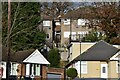
Houses in Cranleigh Close and Broom Mead
Houses built on steep hillside above the River Shuttle and A2.
Image: © David Martin
Taken: 12 Dec 2021
0.09 miles
2
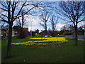
Daffodils and trees, Gravel Hill Close, Bexley, Kent
This lovely clump of daffodils was too good to miss, the leafless trees providing the appropriate early April backdrop.
Image: © Dr Neil Clifton
Taken: 9 Apr 2006
0.12 miles
4
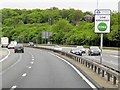
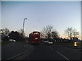
East Rochester Way entering the Low Emission Zone
The Rochester Way Relief Road section of the A2 was opened in 1988.
Despite significant improvements in recent years, London's air pollution is still a concern. The Low Emission Zone (LEZ), which covers much of Greater London, was introduced in 2008 to encourage the most polluting heavy diesel vehicles to become cleaner.
To drive within it without paying a daily charge these vehicles must meet certain emissions standards that limit the amount of particulate matter (a type of pollution) coming from their exhausts. On 3 January 2012, the LEZ emissions standards became more stringent. More vehicles are affected, and those that were already affected need to meet tighter emissions standards (http://www.tfl.gov.uk/roadusers/lez/17678.aspx#tkt-tab-panel-1 Transport for London).
Image: © David Dixon
Taken: 15 May 2013
0.17 miles
5
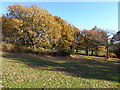
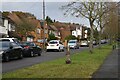
Autumn colours at Hall Place (North)
This is the official name of the open space on the other side of Bourne Road from Hall Place. It slopes uphill from Bourne Road and is relatively quiet. On this clear day there were fine autumnal colours.
Image: © Marathon
Taken: 25 Nov 2016
0.18 miles
6
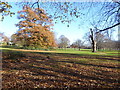
Autumn colours at Hall Place (North)
This is the official name of the open space on the other side of Bourne Road from Hall Place. It slopes uphill from Bourne Road and is relatively quiet. On this clear day there were fine autumnal colours.
Image: © Marathon
Taken: 25 Nov 2016
0.19 miles
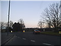
7
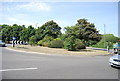
Roundabout on Gravel Hill, Bexleyheath
Image: © David Howard
Taken: 15 Feb 2015
0.19 miles
8

Crayford Telephone Exchange
Situated on Southwold Road Bexley and opposite the Holiday Inn.
Image: © Richard Hoare
Taken: 22 Aug 2010
0.19 miles
10
Roundabout on Gravel Hill, Bexleyheath
Looking towards the Bourne Road exit eastbound
Image: © David Howard
Taken: 15 Feb 2015
0.20 miles